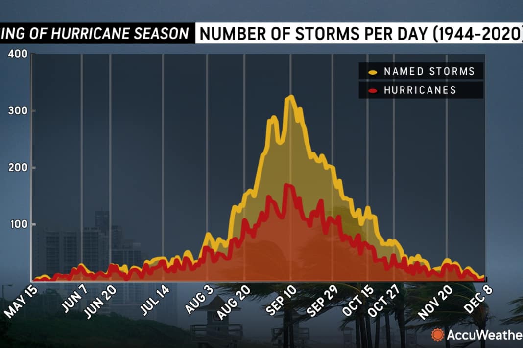


The 2025 Atlantic hurricane season peaked on 10 September, but the most dangerous phase could be yet to come. Meteorologists are watching with growing concern the exceptionally high water temperatures in the Gulf of Mexico, which create the potential for hurricanes to escalate particularly quickly.
Unusual warmth due to lack of storm activity
In contrast to the previous year, the Gulf of Mexico remained virtually unaffected by tropical systems in the summer months of 2025. Only the short-lived tropical storm Barry grazed the region in June. This unusual calm has consequences: without the cooling effect of storms, water temperatures were able to rise to an average of 30°C - values that are close to historical highs.
"The thermal energy content of seawater in the Gulf and western Caribbean has reached almost unprecedented levels," explains Alex DaSilva from weather service provider AccuWeather. "These heat reserves extend into deeper water layers and form the perfect breeding ground for tropical systems."
Increasing risk of lightning intensification
Particularly worrying is the phenomenon of rapid intensification - a process in which the wind speeds of a storm can increase by more than 93 km/h within just 24 hours. This phenomenon makes forecasting more difficult and dramatically shortens the warning time for coastal regions.
The recent past provides alarming examples: Devastating Hurricane Ian, destructive Michael and catastrophic Helene all underwent such lightning intensification. As recently as August 2025, Hurricane Erin (Azores) demonstrated the extreme potential of this phenomenon when its wind speeds increased by a shocking 137 km/h in just one day - a jump from Category 1 straight to Category 5.
High-risk phase expected from the end of September
Meteorologists are forecasting that the second half of September in particular could be critical. "Atmospheric conditions are expected to develop optimally for storm formation at the end of September," warns DaSilva. "Should a system then form in the Gulf or move into it, the conditions are in place for explosive intensification."
AccuWeather's updated seasonal forecasts predict a total of 13 to 18 named storms for 2025, including seven to ten hurricanes. Three to five of these could exceed the threshold for severe hurricanes (category 3 or higher), with wind speeds in excess of 180 km/h.
Increased danger for coastal regions
The coastal areas of Texas, Louisiana, Mississippi and Florida are particularly in focus. However, experts point out that the effects could extend far inland - with an increased risk of flooding and tornadoes, similar to the record-breaking 2024 season.
Authorities are advising residents of vulnerable areas to review their emergency plans and take precautions. The combination of record warm waters and favourable atmospheric conditions creates a situation that requires maximum vigilance.

Lars Bolle
Chief Editor Digital
