

Read the other parts of our Sweden series:
- Part 2: Southern Vänern
- Part 3: The Göta Canal
The Göta Canal is undoubtedly one of the last adventures that can still be experienced on your own keel in our latitudes. For around 400 kilometres, it winds like a blue ribbon through the south of Sweden, through the forests, meadows and fields of the ancient cultural landscape of Götaland. The historic waterway not only connects the two coasts of the Scandinavian country, but also crosses two of Europe's largest lakes, Vänern and Vättern.
So it's no wonder that the entire route has become known as the Göta Canal. However, the section that actually bears this name only makes up the eastern half of the entire route, from Sjötorp on Lake Vänern to Mem, where the canal reaches Slätbaken, which is already part of the Baltic Sea. Those travelling from the Kattegat and starting their journey in Gothenburg, on the other hand, first have the western half ahead of them: the Trollhätte Canal up to Lake Vänern and then the lake itself. Each of the three sections has its own character and would be worth a trip on its own, but together they make the Göta Canal adventure a truly unique cruising experience.
In three parts, we will present the individual sections from west to east in more detail. This article starts with the Trollhätte Canal, which, unlike the Göta Canal itself, has been developed as a modern large shipping route and also allows seagoing cargo ships up to a certain size to pass through to Lake Vänern. Three barrages with a total of six locks have to be negotiated.

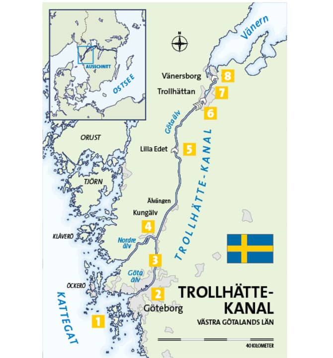
1 The archipelago
The first landfall when approaching Göta älv is not the mainland, but the archipelago off the coast, Göteborgs skärgård. The term garden is apt, as many city dwellers have their summer home on one of the islands. The main fairway divides the archipelago into a southern part with twenty larger archipelagos and a northern part about half the size, which also includes the three popular excursion and holiday islands Björkö, Öckerö and Hönö, all of which have their own guest harbours.
2 Gothenburg
Like many other European seaside cities, this metropolis of millions has changed its waterfront face considerably over the past two decades. It was not the spirit of the times that was responsible for this, but economic necessity: on the sites that were once used for shipbuilding and the storage of general cargo, modern residential space is now growing upwards. Joggers run their laps where stevedores handled cargo. If you pass Gothenburg's "gateway", the 107 metre high Älvsborgsbron, coming from the sea and head further upstream on the Göta älv into the city, you cannot fail to notice this development on the north bank: The Eriksberg shipyard's gantry crane still stands there like a giant red portal. This industrial monument is all that remains of the glorious shipbuilding past. Office blocks and flat blocks now line the former dry dock. Opposite, the large ferries to Frederikshavn and Kiel have their berths. Harbour ferries cruise, pleasure craft and sailing yachts are underway.
Soon the ships of the Maritiman, the Maritime Museum ( www.maritiman.se ), in the first row the destroyer "Småland", which was launched at Eriksberg in the 1950s. This is followed by the modernist wedge-shaped opera house ( www.en.opera.se ) and immediately behind it, in front of the high stem of the four-masted barque "Viking", the largest cargo ship ever built in Sweden, the entrance to the harbour of Lilla Bommen. Here guests will find berths on floating jetties with outriggers or murings ( www.goteborgsgasthamn.se ). The location couldn't be better: The Nordstan shopping centre right next door ( www.nordstan.se ) leaves nothing to be desired when it comes to supplies, and restaurants can be found either there or directly at the harbour. Via Östra Hamngatan you can reach Gustavs Adolfs torg in the city centre in ten minutes and Kungsparken, Gothenburg's green lung, in twenty minutes on foot. Västtrafik is responsible for bus and train services in the city and surrounding area ( www.vasttrafik.se ).
Gothenburg is always worth a visit, newcomers should plan at least two days. The mix of sophisticated elegance, relaxed Scandinavian lifestyle, culture and scene guarantees great memories!
3 The Trollhättekanal
The kilometres of the Trollhätte Canal begin immediately above Lilla Bommen with the passage of the Götaälvbron. The fact that the river has been shaped for large ships is evident not only from the straight stretches over the first few kilometres, but also from the radar reflectors on both sides and at regular intervals on long booms over the water. They mark the fairway for ships, which can be up to 87 metres long and 4.70 metres deep. The Vänermax dimension is based on the usable size of the lock chambers on the 82 kilometres between Gothenburg and Vänersborg.
While industrial areas and shopping centres on both sides initially point to the conurbation of the city, the surrounding countryside soon becomes greener and hillier. The Göta älv now appears very natural, despite the fortified banks and lake markers. No wonder: only ten kilometres of the waterway had to be created artificially. The journey across Sweden has begun!
4 Kungälv
At the mouth of the Nordre älv, which is also navigable but less frequently used (see map), the towers and walls of a massive castle come into view on the port side around 15 kilometres north of Gothenburg: for centuries, Bohus fästning was of central strategic importance in the power struggles for dominance and influence between Denmark, Sweden and Norway ( www.bohusfastning.com ). The impressive complex can be reached in a few minutes from the guest harbour of the small town of Kungälv on the fortress island ( www.gasthamnsguide.se > Search: Kungälv).
5 Lilla Edet
After a journey of around 50 kilometres, the first of the three barrages on the way to Vänern is reached: the Lilla Edet lock has a drop of six metres, with a total height difference of 44 metres along the entire route. There are waiting areas for pleasure craft and the lock staff monitor arrivals by video camera. All locks (and movable bridges) can also be reached via VHF channel 9. Further information is available on the Sjöfartsverket website: www.sjofartsverket.se > Search: Trollhätte channel.
The Lilla Edet guest harbour with floating and mooring jetties is located in the upper water of the lock on the eastern bank. Mooring is alongside or with a mooring ring ( www.lillaedet.se > Search: gästhamn).
6 The sluice staircase
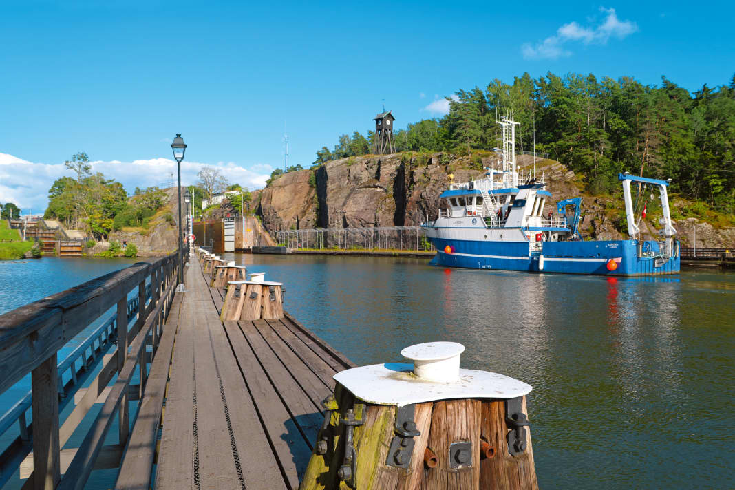
The further north you go, the more the river valley becomes a gorge. At the same place where the Göta älv plunged into the depths with a waterfall in ancient times, it was tamed around 1800 with the first lock stairs. But just half a century later, it had to be replaced by larger, blasted-out new structures. Both lock staircases still exist, right next to the one used today from 1916.
There are a total of four chambers at this point (three connected, followed by a single one) with a drop height of 32 metres. The last chamber also houses the office where the fee for the passage is paid (card payment). The current price is 1000 Swedish crowns per boat, which is just under 100 euros. Those travelling through then moor in the pretty guest harbour of Åkerssjö above, otherwise the journey continues directly. www.vastsverige.com > Search: Marina Trollhättan
7 Trollhättan
For a few kilometres, the canal now leads directly through the town of Trollhättan, which has its own guest harbour on the Spikön peninsula off the western shore, just opposite the lively Strandgatan and the small town centre ( www.vastsverige.com > Search: Marina Trollhättan).
8 Vänersborg
Before reaching Lake Vänern, the last lock in Brinkebergskulle has to be passed, then the entrance to Vänersborg, the administrative centre of the region and important harbour town in the south-west of the lake, is made via Karlsgraben. The full range of services is available here once again before the inland journey ends for the time being and you return to the open water. There is a guest harbour on both the canal and the lake side ( www.vastsverige.com > Search: Marina Vänersborg).
Service
WATER CARDS NV.Atlas Binnen, Volume 8: "Göta kanal & Trollhätte kanal, Passage Vättern and Vänern". Covers the entire route in an east-west direction from Mem to Gothenburg, including the large lakes. Edition: 2016, scale: 1 : 35 000, spiral binding, format: 21 x 42 cm; ISBN 978-3-667-11346-7. Price: €38. www.nvcharts.com
SEA MAPS DK sports boat charts set 14: "Göta Canal with Vänern and Vättern. Gothenburg to Mem with Göta Älv and Trollhätte Canal". Edition: 2020, format: 44 x 60 cm (A2), individual charts, 3 transverse charts, 23 area and detailed charts, area guide with harbour plans and canal charts; ISBN 978-3-667-11915-5 Price: € 79.90. www.delius-klasing.de

The TOP 3 in the district
- Gothenburg: Walk with a visit to the Palmhuset (greenhouse), the Fiskekyrkan (fish market hall) and one of the countless cafés in the cosy, trendy district of Haga.
- Kungälv: In summer, many events and concerts take place at Bohus Fortress. Otherwise, a picnic with a view over the Göta älv is also fine.
- Trollhättan: Car fans won't want to miss the Saab Car Museum, which displays almost all models of the iconic brand ( www.saabcarmuseum.se ).
Distances
Approach (in nautical miles):
- Kiel-Holtenau-Göteborg: 225 nm
- Lübeck-Travemünde-Gothenburg: 245 nm
- Rostock-Warnemünde-Gothenburg: 225 nm
Trollhätte Canal (in kilometres):
- Gothenburg-Kungälv: 19 km
- Kungälv-Lilla Edet: 35 km
- Lilla Edet-Trollhättan: 19 km
- Trollhättan-Vänersborg: 15 km
- Vänersborg-Sjötorp (start of Göta Canal): 115 km
Total distance (Trollhätte-Canal Gothenburg-Vänersborg): 88 km
More about travelling across Sweden:
- Part 2: Southern Vänern
- Part 3: The Göta Canal

