Across Sweden Part 2: Vänern (southern part) - By motorboat across Sweden's largest lake
Christian Tiedt
· 14.11.2022


Read the other parts of our Sweden series:
- Part 1: The Trollhättekanal
- Part 3: The Göta Canal
It's a sight that Central Europeans have to get used to: a lake where you can't see the other side. Just an empty horizon. Endless expanse. If you want to be on the safe side, try the water: fresh and sweet, not a trace of salt. To cross the south of Sweden on your own keel, you have to pass it: Lake Vänern. With an area of around 5500 square kilometres, it is twice the size of Saarland - and ten times the size of Lake Constance.
140 kilometres lie between Vänersborg in the south and Karlstad in the north. Sea-going cargo ships travel along this route, coming up from Gothenburg via the locks of the Trollhätte Canal. The coastline of Lake Vänern measures almost 2000 kilometres, if all the bays, sounds and islands are included. And the islands are a dime a dozen: there are said to be 22,000 of them - from the largest, Torsö, to the smallest, wave-washed, nameless rocky outcrop.
More gigantic bodies of water can only be found inland in Europe further east in Russia: Lake Ladoga and Lake Onega occupy the top spots. But then comes Lake Vänern. And so it forms the great contrast in the gallery of waterways from coast to coast, the impressive piece of lake between the tranquil landscape paintings of the Trollhätte Canal and Göta Canal.
With these dimensions, Vänern is certainly more than just an area in itself. Guests who bring a few weeks with them during the short summer - because they are travelling with a trailer, for example - can not only explore the lake itself, but also take a detour or two. For example, to the equally beautiful Dalsland Canal (more on this later). Skippers travelling between the west and east, on the other hand, will generally limit themselves to the southern part of Vänern. Even the shortest connection between Vänersborg and Sjötorp, where the Göta Canal begins, measures around 150 kilometres - a stage for which you should allow at least three days. And - as the second part of our "Across Sweden" region portrait on the following pages shows - much more. At Vänern, the only limit is the horizon.
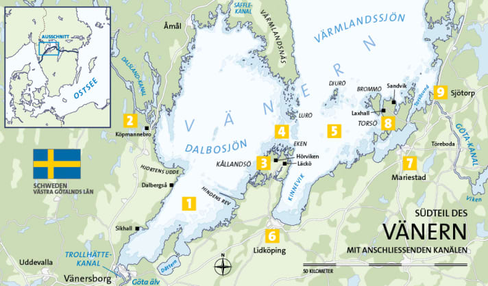
1 Lake Dalbosjön
The first part of our journey ended in the industrial and harbour town of Vänersborg. From the Kattegat in Gothenburg, the route followed the Trollhätte Canal with its six locks to its inland end here in the far south-west of Lake Vänern. The journey now continues on the southern part of Dalbosjön, which in turn forms the western half of Vänern. From Vänersborg, the lake opens up like a funnel to the north-east in a bay around 40 kilometres long. The buoyage and lighting leave nothing to be desired, as freighters and tankers of the Vänermax type with a draught of up to 4.70 metres also sail on the lake.
Despite its large expanse, Vänern is shallow and rocky, especially in areas close to the shore, and there are numerous individual obstacles and reefs that should be avoided by those unfamiliar with the area, even in smaller boats. One particular obstacle of this kind is Hindens Rev, which protrudes into Dalbosjön like a stone needle for almost seven kilometres and continues under water - a hard remnant of a terminal moraine that was formed during the last ice age. The only two marinas in this part of the lake (apart from Vänersborg) are in Sikhall ( www.batsidan.com/hamn/sikhall ) and a little further north in Dalbergså ( www.dalbergsa.se > gästhamn) on the western bank.
After passing the narrow section between Hindens Rev and Hjortens Udde, Dalbosjön opens up further and the route is free to head east towards the island of Kållandsö (and beyond to the Göta Canal) or north-west to the Dalsland Canal.
2 The Dalsland Canal
The water system of the Dalsland Canal begins at Köpmannebro - certainly one of the most beautiful inland waterways in Europe. The name is deceptive: of its approximately 250 kilometres, only twelve (with 31 locks) are man-made. If you include all the tributaries, you end up with 400 kilometres - all the way to Norway. The historic Håverud aqueduct, opened in 1868, is also one of Sweden's best-known engineering monuments. ( www.dalslandskanal.se )
3 The island of Kållandsö
is the second largest in Vänern, whereby the sound in the south is so shallow even in the navigation channel that it can only be navigated by very small open pleasure craft. The most attractive side is in the north anyway: The gästhamn of Läckö is located right next to the imposing castle in a park-like landscape. The history of the baroque building dates back to the Middle Ages, and opera performances take place in the summer. Even older are the Bronze Age rock carvings in the surrounding area ( www.lackoslott.se/camping-gasthamn ). Alternatively, skippers can also find a berth at Kållandsö Marina in Hörviken. ( www.kmbk.se )
4 The archipelago
North of Kållandsö, the transition between Dalbosjön and Värmlandssjön forms the waist of Lake Vänern. Just twenty kilometres lie between the island in the south and the tip of the Värmlandsnäs peninsula in the north. It is so flat here that two archipelagos protrude from the lake like a belt: Ekens skärgård in the south and Lurö skärgård in the north. Both consist of hundreds of small and tiny islands, some forested, most bare. Almost all are uninhabited. A fascinating landscape of rock and water, formed by the weight of former glaciers. Both archipelagos are named after their respective largest islands, and Lurö not only has the only guest jetty in the area; you can also spend the night in a former lighthouse building and bathe from the floating sauna. Booking recommended! ( www.lurogast.se )
5 Lake Värmland
After the shallow lagoons of the archipelago, there is now "open sea" again to the east; Värmlandssjön is even larger than Dalbosjön: there are almost 100 kilometres between north and south. In addition, the deepest part of Lake Vänern, at 106 metres, is about 25 kilometres south of Karlstad. For skippers heading towards the Göta Canal, however, only its southern end is important. There is a northern and a southern route. On the northern route is the Djurö National Park, a small group of archipelagos with no jetties but several good natural harbours for anchoring. The best harbour, Malbergshamn on the main island, is approached from the north. From there, there are signposted tours ashore: a small paradise between "rattling stone beaches" of pebbles and pine forests - if you're lucky, you might spot roe deer. ( www.sverigesnationalparker.se > Search: Djurö)
6 Lidköping
If you want to include a town for a change (or need to get supplies), you can definitely choose Lidköping, which, however, is only at the very southern end of the almost 20-kilometre-long Kinnevik. The centre is a quarter of an hour's walk from the guest harbour of Segelsällskapet Westgötarne. ( www.sswlidkoping.se > gästhamnen)
7 Mariestad
Mariestad, named after a German princess, is the more attractive (and closer) option for a shore excursion with a stroll through the town: here the gästhamn is located directly between the river Tidan and the old town with cafés and beach bars right in front of the boat ( www.hamnmagasinetmariestad.se ). But a few more steps won't hurt either, for example to the Gamla Ekudden nature reserve or to Karlsholme Folkets Park with the Sjöterrassen restaurant.
8 The island of Torsö
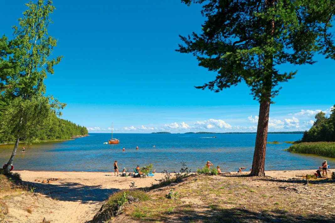
The largest island in Vänern has only been connected to the mainland since 1994: The Torsöbro spans the sound of the same name in an elegant arch. There are two attractive spots for a last night on the lake: firstly, the small guest harbour of Laxhall on the picturesque Brommösund on the west side of the island, which even has a chic hamnkrog with an exciting map ( www.laxhall.se ). The second is the magnificent Sandvik anchorage in the north, without a restaurant, but with a sandy beach, forest all around and an unobstructed view of Lake Vänern.
9 Sjötorp
This is where the Göta Canal begins (or ends), depending on where you are coming from. Protected by piers, gästhamn belongs to the canal company and is located below lock number 1, where you can get your ticket for the next highlight of the journey from the keeper's house. ( www.gotakanal.se )
Service

WATER CARDS NV.Atlas Binnen, Volume 8: "Göta kanal & Trollhätte kanal, Passage Vättern and Vänern". Covers the entire route in an east-west direction from Mem to Gothenburg, including the large lakes Vättern and Vänern. Edition: 2016, scale: 1 : 35 000, spiral binding, format: 21 x 42 cm; ISBN 978-3-667-11346-7. Price: 38 €. www.nvcharts.com
SEA MAPS DK sports boat charts set 14: "Göta Canal with Vänern and Vättern. Gothenburg to Mem with Göta Älv and Trollhätte Canal". Edition: 2020, format: 44 x 60 cm (A2), individual charts, 3 transverse charts, 23 area and detailed charts, area guide with harbour plans and canal charts; ISBN 978-3-667-11915-5. price: € 79.90. www.delius-klasing.de
The TOP 3 in the district
- Lurö Sweat in the archipelago in the floating sauna - on a bright Nordic summer's night. Lurö Krog, the restaurant on the island, is even open until 1am.
- LäcköA walk through cultural history, from the Bronze Age to the present day, in the most beautiful natural surroundings. Followed by coffee and cake in the converted old stables of the castle.
- Mariestad Perhaps the nicest little town on the whole of Lake Vänern is well prepared for visitors and offers a lot of flair. One of Sweden's favourite beers is also brewed here: Mariestads.

Distances
- Vänersborg-Läckö (island of Kållandsö): 68 km
- Läckö-Lidköping: 22 km
- Lidköping-Mariestad: 50 km
- Mariestad-Sjötorp (start of Göta Canal): 20 km
- Vänersborg-Sjötorp (direct route): 115 km
- Vänersborg-Sjötorp (with stage harbours): 160 km
Total distance (Trollhätte Canal and Vänern): 250 km
Further parts of our Sweden series:
- Part 1: The Trollhättekanal
- Part 3: The Göta Canal

