

Read the other parts of the travel report:
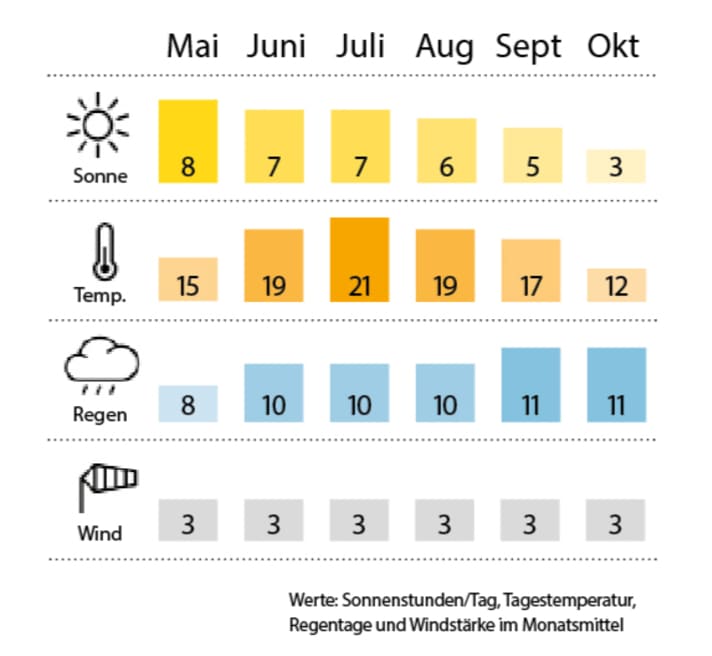
Pouring rain. This is not the image we had in our heads of the "Norske Riviera". But it has to be said that even the hardened locals only refer to their south coast in this way with a wink. On the other hand, if you live in the Arctic Circle, the mild climes "down here" around Kristiansand may well have a Mediterranean feel to them.
It's no use: After we had a lot of wind in the first week of our trip with the "Rolling Swiss 2" from the Cruising Club of Switzerland on the way from Aalborg in Denmark via Læsø to Skagen, it has now become really uncomfortable - fortunately only after our nightly jump across the Skagerrak to Kristiansand.
For breakfast, there are six to seven Beaufort from the east, the water splashes over the jetties of the guest harbour. A really big Princess upwind is pushing so hard on the edge that she flattens one of her metre-high fenders after the other. Although our route from Kristiansand to Arendal has already been plotted, we decide not to set sail. Harbour day! Tomorrow should at least be a little better.
After a walk through Kvadraturen (the lively city centre district of Kristiansand), we decide to go to the cinema in the evening. But before that, the two Norwegians from the rather frail-looking cutter opposite board us: Atle and his much quieter colleague are on their way to Stavanger with their new €8,000 acquisition to convert the rotten boat into a houseboat (or something like that). They don't even have money for chairs or glasses. But for a bottle of whiskey a day. Bob Marley smiles away the rain: "Don't worry about a thing!" Then to the Nordisk film cinema on Vestre Strandgate: "Wonder Woman" cuts a fantastic figure in 3D. On the way back to the boat, half of Kristiansand runs into our arms with pink wristbands: everyone is already in a festival mood. Tomorrow sees the start of "Palmesus", "Scandinavia's biggest beach party". Have fun!
From Kristiansand to Arendal
It's the last day on board for crew member Christoph: his desk is calling. But first we have to get to Arendal, from where he wants to take the train to Oslo tomorrow. The capital is also the destination for the rest of us - but not for another week and on our own keel.
It's still blowing quite well, but at least the sky is brighter. Around 40 nautical miles lie ahead of us, including Blindleia, the archipelago fairway between Kristiansand and Lillesand. We cast off at 0850 and follow the plotter course zigzagging north-eastwards. Again and again wind and waves from the front, but also calm corners with mirror-smooth water. Holiday homes behind every rocky outcrop, only accessible by water. Buoyage: no sign. Instead, there are beacons with black iron flags pointing the way to the fairway. No wonder the two lads from the jetty in Kristiansand have been forced to sail their cutter here. The scale of the nautical charts is microscopic. In this already black and grey landscape, you have to pay close attention to where you're going. Even sober...
This does not detract from the beauty of the route from Kristiansand: very narrow passages less than twenty metres wide, a labyrinth of rock faces. It does indeed open up. So at 11.30 a.m. we take the dinghy ashore so that Morten can take photos from the bridge between Justøya and the mainland. A seal takes an interest in us. After the dinghy is back in the davits, we pass Lillesand (which looks very pretty from the water). This is followed by an open stretch with sunshine! Deep blue sea, bright white whitecaps, pure force of nature!
We reach Arendal at 1630 hrs. The last place in the town harbour right in the centre is snatched away by a Scand, so the only place left is the rough outer jetty of Gjestehavn to the west. No matter. At least it's warm enough for shorts now! As dusk falls, the sound is full of dancing and wandering lights: boats instead of cars. Arendal is a town of islands - but almost without bridges. The five of us have pizza on the aft deck on our last evening, accompanied by a gentle breeze. The Riviera is getting closer.
To Lyngør
Christoph leaves the boat at 0915, a big farewell. There are now four of us left: skipper Marc, co-skipper Isabelle, photographer Morten and me. After a major engine check and thorough filter cleaning, we cast off the lines in Arendal. North-eastwards with weekenders across Tromøysundet. At Eydehamn, the sky-high lattice legs of an "offshore hotel" - a residential platform that is otherwise at sea and is waiting here for its next assignment.
The island of Tromøy ends at the headland near Gitmertangen, then onwards through the archipelago in great weather: foam-covered rocks, hardly any sea marks, even fewer stone beacons in black and white. Lots of traffic between Borøya and Sandøya. A constant stream of Nordic boat types: Nordkapp, Windy, Nimbus, Targa. On board, sunglasses and bikinis, life jackets on bare torsos. Children wave to us.
We discuss our destination for the day and decide to stay in Lyngør - if we can find a place. We are lucky. Or rather: we arrive at our destination early enough: it's just 1.325 pm and there are still places available right on the pier in front of the "Seilmakerfruens Kro". A very cosy affair - albeit at the hefty price of 400 Norwegian kroner, or around 40 euros.
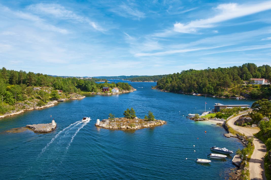
But Lyngør and its small island (called Lygøya) really are a gem: a single footpath leads along the shore, lined with white wooden houses, blossoming flowers and bushes, followed by ferns and rocks. A watchtower stands on the highest hilltop, a signalling station from Napoleonic times, from which the naval battle off the island in 1812 was also observed, when the Danish frigate "Najaden" was surprised by a Royal Navy ship of the line.
Take the dinghy to the Lyngør Fyr lighthouse and around the islands. In the evening, we go to the pub on the pier; the "Kro" used to be used for fish processing, so the floor, made of heavy planks, slopes down towards the water so that it can be easily rinsed off. The prices are once again hefty, just like in Norway, but the mussels (called blåskjell here) are also really well made. The service is also very friendly. All in all, there is a lot of smiling on the island. Maybe there's no stress here? I wish there was.
After dinner, we walk to the "sunken beach" and the mossy football pitch (you can play football anywhere). As a belated sundowner, we treat ourselves to a summer beer with the fitting name "Skjærgårds Pils". First mosquito spotted.
To Kragerø
The wind is back, around four Beaufort from the north-west with rough gusts that could cause us problems later in the day. But it's not far today. We leave beautiful Lyngør through the Østregapet. The north-west is pushing and the sky is clear again after a hazy night. At Risør we head back into the archipelago, but we don't call at the village and instead continue directly via Østerfjorden and Grønholmgapet in the direction of Kragerø. Less busy than yesterday, probably because of the waves, but still lots of larger pleasure craft in transit off the coast. At the Stangbåen beacon we head inland to Kragerø, where we go alongside for a stopover in the guest harbour at 1250 hrs.
Of course, there is a holiday atmosphere here too; the narrow streets with the densely built wooden houses are reminiscent of Cornwall or rather New England. Lots of holidaymakers. Ice cream cones on the benches and glasses of beer in the pubs along the sound between the mainland and the island. Galleries with art full of light, nautical antiques, all kinds of stuff. The bronze sailor in front of the rådhus leans relaxed against his steering wheel.
Back to the boat via the gun-armed fort of Gundersholm, so that we are on our way again by 1420 hrs. Exciting cruise now through the offshore archipelago with a holiday home on every rock, no matter how small. From the proverbial four (wooden) walls to the designer villa, everything is there. Some rooms have a view of the lake on all four sides! Sunday coffee steams on the terraces and Norwegian pennants flutter in the wind.
The "Rolling Swiss 2" pushes through the Skåtøysund and between Skåtøy and Oterøy, then our actual destination comes into view directly ahead, the island of Jomfruland, elongated and flat. A white lighthouse rises out of the dark forest, with meadows stretching down to the water in front of it. A sight reminiscent of Denmark that hardly seems to fit in with this rocky coastline.
But the floating jetty is shaken by wind and waves, boats tear at their mooring lines. Anything but suitable for the big "RS2"... More than a few photos from the water are not possible. So with a heavy heart we return to Kragerø, where we moor at 1550 hrs, this time in the lee of Kanoneninsel (and another large Princess). We'll try again tomorrow.
In the evening, after we have eaten on board, we are drawn to the veranda of the "Lille Kragerø Pub", where "Nordlands" is served on tap and the silver-haired old bikers from the "Stella Polaris MC" introduce a few Germans and Swiss to some important local customs late at night...
To Jomfruland
We take a shower with a sore head. But the wind only gently caresses the innocent blue sky, and so we set off at 1000 o'clock much fresher to make the second attempt to Jomfruland. This time with success. The floating jetties and the old ferry pier at Tårnbrygga Café have long since dried out again and once ashore we realise just how hot it is today. The only road on the island takes us through the forest. Black iridescent giant flies buzz around us. If they got an appetite for us, we'd be finished...
Suddenly the oaks end and round stones cover the ground. Even the walls of the few houses are adapted to this and seem to grow out of the ground. The eastern beach and the Skagerrak, a panorama like in Greece: blue mountains on the horizon, dry bushes sprawling between gneiss and granite. We are standing on the stony ridge of a terminal moraine, formed by the last ice age. Gnarled driftwood serves as a bench for daydreaming. Morten is looking for souvenirs.
Then back to the lighthouse; there are actually two, an old one (without a lantern) and a new one. Climb up the narrow spiral staircase, pay at the top. Picture gallery of Jomfruland's weather-beaten lighthouse keepers. Many served here for twenty years, some even longer. Beautiful view of the much friendlier west coast with its meadows and beaches and the archipelago beyond. An aerobatic plane loops over the harbour, which has already filled up again. Summer is finally here - and it's here to stay.
Service
Precinct information

Cruise stages
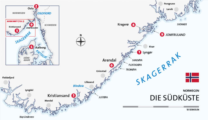
- 5. Kristiansand - Arendal: 41 nm
- 6. Arendal - Lyngør: 20 nm
- 7. Lyngør - Kragerø: 35 nm
- 8. Kragerø - Jomfruland: 6 nm
- 9th Jomfruland
- Total distance (second leg): 102 sm
Tips
▪Arendal: If you arrive in time, you can get a spot in the city harbour - with bars and restaurants all around.
▪ Archipelago: The harbour handbook (see literature) lists a whole series of natural harbours. A night on the rocks is an exciting contrast.
▪ Jomfruland: Can also be easily reached by ferry from Kragerø ( www.fjordbat.no ). The island also offers bike hire.
Weather/climate

Literature
Harbour guide:"Havneguiden 2. Langesund - Lindesnes" by Hanne and Jørn Engevik, 2014. Nautical and tourist information. Norwegian/English. 278 pages, aerial photos, plans, format: 25.7 x 33.2 cm, spiral binding, ISBN 978-82-92284-89-6. www.hansenautic.de
Official recreational craft chart sets: "Series 03: Sandefjord - Porsgrunn - Torungen fyr" and "Series 04: Torungen fyr - Lindesnes". Publisher: RS/Nordeca. Scale: 1 : 50 000, size: 47 x 36 cm, transparent cover, oversleeve (1 : 150 000). www.hansenautic.de
Travel guide: "Norway. The South" by Michael Möbius and Annette Ster, 2016. DuMont Travel Paperback: 296 pages, many photos, format: 11.9 x 18.6 cm, paperback, ISBN 978-3-77017-412-6. shop.dumontreise.de
The club
We travelled with the Cruising Club of Switzerland (CCS). With around 6,500 members, the CCS is one of the largest water sports clubs in Switzerland and is a leader in the field of offshore training. The motorboat department forms a separate division within the club with its own yacht, which is used for training and cruising trips. www.ccs-motoryacht.ch
Our boat
Type: Trader 42 (GRP semi-planing) - Length: 13.30 m - Width: 4.30 m - Height: 3.80 m - Draft: 1.20 m - Berths: 6 (3 double cabins) - WC/shower: 2/2 - CE category: A - Motorisation: 2 x 380 hp - Special equipment: VHF radio system, plotter with radar and AIS overlay, generator, EPIRB, dinghy on davits
Driving licence
Skippers on their own keel and with a German residence require an official recreational craft licence in the area.
The precinct
▪The Norwegian south coast: Around 150 nautical miles lie between Norway's border with Sweden and the country's southernmost point at Cape Lindesnes. The coastline in between forms the northern edge of the Skagerrak and the eastern part of Norges sydkust. The area is characterised by rugged rocky coastlines with offshore islands and skerries. There are nowhere near as many navigation marks as in neighbouring Sweden, and there are hardly any buoys in particular. Land-based beacons are painted in black and white and are therefore not always easy to recognise. On the other hand, the main fairways are continuously lighted.
▪The Blindleia is a largely sheltered archipelago fairway between Gamle Hellesund (about 10 nautical miles east of Kristiansand) and Lillesand. It is about 12 nautical miles long, about half of which is the passage between the mainland and the larger island of Justøya. Due to the many branching routes between the smaller islands, precise positioning and navigation is particularly important. Although most sections are easy to recognise and marked with beacons and lights, there are always points that require close attention. Traffic can be particularly heavy in summer, with passenger ferries and work boats also using the route. Caution is therefore advised in places where visibility is poor.
Our harbours
Booking and reservation are recommended during the season, especially for motor yachts. Kristiansand: Gjestehavn, kristiansandgjestehavn.no ▪ Arendal: Gjestehavn, gjestehavna.no ▪ Lyngør: Seilmakerfruens Kro, seilmakerfruenskro.no ▪ Kragerø: Gjestehavn, www.visitkragero.no ▪ Jomfruland: Tårnbrygga, www.visitkragero.no
Also interesting:
- Charter-Journal: Norway - Telemark Canal
- Report: Wooden boat festival in Norway - A harmonious idyll
- Journey: From Stockholm to the north

Christian Tiedt
Editor Travel
Christian Tiedt was born in Hamburg in 1975, but grew up in the northern suburbs of the city - except for numerous visits to the harbor, North Sea and Baltic Sea, but without direct access to water sports for a long time. His first adventures then took place on dry land: With the classics from Chichester, Slocum and Co. After completing his vocational training, his studies finally gave him the opportunity (in terms of time) to get active on the water - and to obtain the relevant licenses. First with cruising and then, when he joined BOOTE in 2004, with motorboats of all kinds. In the meantime, Christian has been able to get to know almost all of Europe (and some more distant destinations) on his own keel and prefers to share his adventures and experiences as head of the travel department for YACHT and BOOTE in cruise reports.

