
When the red kite makes its steady circles over the river and no sound disturbs the silence except the constant gurgling of the stern water, it is difficult to imagine that the lower reaches of the Havel were once a busy transport route. As the fastest navigable connection from Berlin to the Elbe, and onwards to the seaside city of Hamburg, it played a not insignificant role in freight transport.


Dozens of customised barges at the bulwark
Havelberg, the old Hanseatic town, whose Romanesque brick cathedral still towers high above the confluence of the two rivers, was even considered the most important overnight stop for boatmen between the two metropolises. Old photographs show dozens of rustic barges moored close together at Havelberg's bulwark, so that - with a little skill - you could soon have got from one bank to the other without getting your feet wet.
But then, in the first half of the last century, the Mittelland Canal was built and - as an extension and direct connection - the Elbe-Havel Canal from the Elbe to Plaue. The modern Magdeburg waterway intersection, which was only fully completed after reunification, now forms the hub for inland shipping between the Ruhr, Oder and Elbe with its trough bridge and descending locks.

The water can do what it wants again
On the way to Berlin, the Lower Havel was literally "left behind" - a stroke of luck, not only for the river itself, but also for water hikers: a renaturalisation project between Plaue and Havelberg has now been underway for almost ten years. The era of cargo ships is now a thing of the past, even if navigability is maintained.
Nevertheless, the water is once again allowed to do as it pleases. Lowlands become wetlands, oxbow lakes come back to life and the traditional floodplain landscape returns. This creates a refuge for endangered species and helps to protect against flooding through natural floodplains. If you want to hear the clocks ticking more slowly, the Lower Havel is the right place for you. You will perhaps only find so much nature on your own keel on the Peene in Mecklenburg-Western Pomerania.
The fact that the region will soon become even more attractive is due to an upcoming major event: in 2015, the Federal Horticultural Show will make the Lower Havel blossom. For the first time, there is not just one venue, but five - and four of them are located directly on the river: Brandenburg, Premnitz, Rathenow and Havelberg. Blossoming splendour, garden art and pure nature in constant alternation - what cruise can offer that? We took a look around the area by charter boat to get an idea of what to expect next year. This much in advance: it should be worth it!
Sunday atmosphere on the Havel in Potsdam
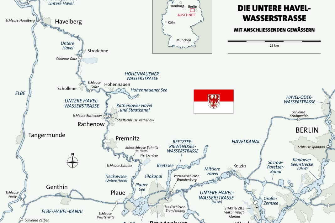
Our journey begins a good distance further east in Werder. The southern bend that the river takes here - actually a chain of lakes - is called the Potsdam Havel. Commercial shipping on the east-west route of the Lower Havel Waterway - UHW for short - takes the Sacrow-Paretzer Canal, which is not particularly picturesque, but saves around ten kilometres and many bends.
With our charter boat, a classy and fully equipped Jetten 37 AC from Yachtcharter Werder, we leave the jetty of the Vulkan Werft marina at PHv-km 10.3 under a blue May sky. There's a lot going on on the water on this Sunday, one of the first sunny weekends of the year: white sails are dotted across the Großer Zernsee, rowers are putting on their oars, while motorboats are already anchored under the shore or purposefully heading for their "favourite spot", which is still free.
The suburban lock shows green
We steer under the Berlin motorway ring road across the reed-lined fairway of the Kleiner Zernsee and join the main course of the UHW at Ketzin, pass a bulky Polish slipway with rusty scrap metal cargo and then follow the buoy line towards Brandenburg, which is waiting for us about 20 kilometres to the west. Black clouds soon gather above us and unload with lightning, thunder and a heavy thunder shower. But when we can already see Brandenburg, we are doubly lucky: the last drops are falling and the suburban lock shows green - we can enter immediately. While commercial shipping uses the expanded Silokanal to pass through the city, we take the "diversions" via the Brandenburg Niederhavel, which is well worth seeing.
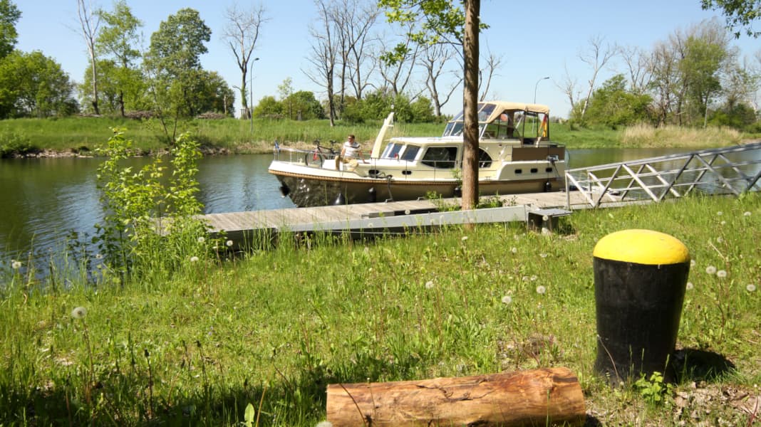
The old town has two public jetties that are only around 100 metres apart: one at the Sandtor near the Jahrtausendbrücke bridge and the other at the Water hiking rest area at the Slavic village. The harbour master, who has just sauntered up and is responsible for both, tells us: "It's cheaper here, nicer back there." So we untie the mooring lines and move our steel displacer from the promenade to the green area, where it will spend the night on a solid floating dock in good company with two replica Slavic clinker boats. (Mooring fee: 1 euro per metre, electricity: 1 euro, WC: 50 cents, shower: 1 euro, Open-air museum.
To the BUGA in the "Cradle of the Mark"
Just 400 metres away on the other bank, one of Brandenburg's BUGA areas is currently under construction: 30 themed gardens "with the resources of life" will be created on the former Packhof site. On the Marienberg, also just a few hundred metres away, roses will bloom and perennials of all kinds will grow. (Information on all five BUGA 2015 locations: www.buga-2015-havelregion.de). If you prefer a real marina for your visit, you will find one at Havel Marin (UHW-km 55) and in the Marina Schooner's weir (access via the Brandenburger Stadtkanal, BrK-km 56.4) full service, in the second case also a boat refuelling station with diesel and super.
A lot has happened in the city since our last visit five years ago, but there is still a lot of renovation going on. Old industrial ruins on the waterfront are being gutted or making way for new, modern housing on the waterfront. In between, the old round towers dating back to the Middle Ages are a reminder, together with St Peter and St Paul's Cathedral, of the power that once emanated from these walls and, as the "Cradle of the Mark", gave its name to an entire part of the empire.
GDR plaster on Plau Castle
The next day, we cross the Stadthavel to the Breitlingsee, where things get really busy. A steel grey sky, lots of wind, but no rain. At Plau Castle - still with its grey GDR plaster - we soon turn off the main fairway to the north. Here, at UHW-km 68, the actual Lower Havel begins. The motor tanker in front of us, on the other hand, continues along the Elbe-Havel Canal towards the Elbe.
The first ten kilometres follow Lake Tieckow, which is rarely wider than 300 metres and often narrower. Anglers stand on the shore, bright light green birch and alder alternate with sandy pine forest on the higher terrain. An old watchtower from the former Briest airbase stares out of empty windows across the river. The site is now used peacefully by a solar company, which has erected Europe's largest photovoltaic plant there.
Inclined chamber walls in Bahnitz
Behind Pritzerbe, which is connected to the boathouse of the same name has a marina with guest berths (fixed pontoons with boxes, electricity, water, sanitary facilities), we first pass the town's ferry, which is not free to sail, and finally reach the first of four locks on the way to Havelberg at kilometre 82.
The Bahnitz lock is designed with sloping chamber walls due to the soft bottom, so you should be careful not to sit on it, especially when passing through the valley. At 200 metres long, its dimensions are a reminder that entire towed convoys used to pass through here. Both points also apply to the following locks on the main route. You can register with the Rathenow remote control centre via the intercom system on the waiting jetty, by calling 03385-53 98 71 or by radio (Bahnitz: VHF channel 04, Rathenow: 03, Grütz: 02, Garz: 01).
Narrow loops, flat floodplains
Now the river becomes much narrower, its bends winding more tightly through the flat floodplain landscape. We are at high tide: the actual shoreline is barely recognisable, closed stretches of water extend far into the hinterland and make villages in the distance look like islands. Oxbow lakes branch off and flow in, sometimes overgrown, sometimes tantalisingly expansive. Gnarled trees cling to the firm spots, many of which lost the battle against renaturation a long time ago and now only stretch their bare, grey branches into the sky. You have to look closely at some of the buoys: Like floating islands, they are surrounded by overgrown weeds. Right now, you have to keep a close eye on the fairway!
Premnitz, which lies at UHW km 91 on the eastern bank, will also be hosting the BUGA 2015 - and boaters will be right in the middle of it all here too: Both mooring facilities, the guest jetty directly on the river and also the small, sheltered town harbour, are adjacent to the integrated display areas on the riverbank promenade: day gardens, sun perennials and lush grasses will illustrate the energy of renewable raw materials. There is also a nature trail through the floodplain forest that is so typical of the region. We want to stop here on our way back, but our destination for today is the old optics town of Rathenow.
The optics town of Rathenow
The way into Rathenow is via the old arm of the Rathenow Havel and the city canal, while the actual UHW passes the centre to the west via the lock canal (with the Rathenow lock). The best guest berths are at the Old Harbour (harbour wall with floating jetty, mooring fee: 1 euro/m, electricity: 0.50 euro/kWh, showers: 2 euro, key and registration at the - incidentally excellent - restaurant "To the old harbour" ).
From this berth in the upper water of the historic Rathenow city lock, it is again only a short walk to the BUGA exhibitions: The entrance to the "Weinberg" is located directly at the harbour, then the 300 m long, spectacularly curved pedestrian bridge leads to the "Optikpark" on the Havel island. The park was created in 2007. It documents the history of the optical industry, which used to be so important for Rathenow, using the means of landscape architecture:
Flowers in all colours of the spectrum, installations with optical illusions and light-refracting steles hark back to a time when astronomical telescopes, photographic lenses and high-performance lenses for beacons were exported from the Havel to the whole world. For next year's BUGA, water lily and lotus fields, a flower cascade and play landscapes for children will be added.
Head for Havelberg Cathedral
"From cathedral to cathedral - the blue ribbon of the Havel" is the motto of the Federal Horticultural Show. On the one hand, this refers to Brandenburg Cathedral, and on the other to Havelberg Cathedral. We get to see it the next day, enthroned on its hill, even though we are still many kilometres away from the river.
In the morning we had passed the junction of the Hohennauen waterway, most of which is formed by the only real lake on the 80 kilometres between Plaue and Havelberg (for the detour, see the information box on the next page), and at lunchtime, after the Grütz and Garz locks, we also passed the small village of Strodehne with its water hiking rest area.
Now, in the afternoon, we have reached the destination of our outward journey, from here we will return the same way, with stops in Hohennauen and Premnitz. After 133 kilometres we stop at the Havelberg marina (floating jetties, fee: 1.20 euros/m, electricity: 1.50 euros flat rate). The first shore leave takes us up to the Domberg, where a monastery garden is being laid out for the BUGA; the perfect place to take some time out - with a sweeping view over the Havel floodplains.
CHARTER COMPANY AND BOAT
The company
Yacht charter Werder has a fleet of almost 30 motor yachts and cabin cruisers of various sizes. There are four charter bases to choose from: Mirow and Lychen (Mecklenburg Lake District), Zehdenick (Upper Havel) and the main base in Werder. One-way trips are possible. Contact: Yachtcharter Werder, A.-Damaschke-Str. 56-58, 14542 Werder/H., Tel. 03327-54 90 72.
Charter boat
In the case of our chartered Jetten 37 AC (built in 2013) is a modern, fully equipped steel displacement yacht with a length of 11.36 metres and 4+2 berths. The yacht has bow and stern thrusters. Weekly prices 2014: 1160 to 2270 euros.
INFORMATION ABOUT THE DISTRICT
Waters
Lower Havel waterway from the confluence with the Spree to the confluence with the Elbe. Length: 148.5 km, locks: 6, maximum speed: 12 km/h, 25 km/h on lakes and lake-like widenings outside the 100 m wide bank protection strip, clearance height: 4.26 m, water depth: official fairway depth depending on water level, available at www.elwis.de
Potsdam Havel from the junction to the confluence with the Lower Havel Waterway. Length: 30 km, no locks, maximum speed: see above, clearance height: 3.51 m, water depth: see above.
Brandenburger Niederhavel from the junction to the confluence with Lake Plau. Length: 7 km, no locks, maximum speed: 8 km/h, clearance height: 4.22 m, water depth: see above.
Rathenow Havelwith city canal; from the junction to the confluence with the Lower Havel Waterway. Length: 3.9 km, locks: 1, maximum speed: 8 km/h, headroom: 3.90 m, water depth: see above.
Hohennauen waterway from the junction
from the Lower Havel Waterway to Ferchesar. Length: 11 km, no locks, maximum speed:
8 km/h, 25 km/h on lakes and lake-like widenings outside the 100 m wide bank protection strip, clearance height: 3.82 m, water depth: see above.
Authority
The waterways described are the responsibility of the Brandenburg Waterways and Shipping Authority: Brielower Landstr. 1, 14772 Brandenburg/H., Tel. 03381-26 60. www.wsa-brandenburg.wsv.de
Cruise literature
- Harbour guide for Berlin and Brandenburg. By Robert Tremmel. Harbours and moorings on the Spree, Dahme and Lower Havel, with tourist information. Seenland Magazin: 214 p., hardcover, ISBN: 978-398146-048-3; 34.90 euros. www.ferienwissen.de
- Inland Charts Atlas 3: Berlin and Brandenburg. 54 p., 31 maps (A3 format), scale: 1:40 000, spiral binding, ISBN 978-3-944082-00-4; 39,90 Euro. www.kartenwerft.de
Cruising stages
Werder/Havel ▹ Brandenburg/Havel ( 1 lock ) 37 km
Brandenburg ▹ Rathenow ( 1 lock ) 49 km
Rathenow ▹ Havelberg ( 3 locks ) 47 km
Havelberg ▹ Hohennauen ( 2 locks ) 42 km
Hohennauen ▹ Premnitz ( 1 lock ) 32 km
Premnitz ▹ Werder ( 2 locks ) 68 km
Total: ( 10 locks ) 275 km

