Portrait of the Strelasund region: Harbours and highlights between Stralsund and Rügen
Strauch Morten
· 09.08.2022


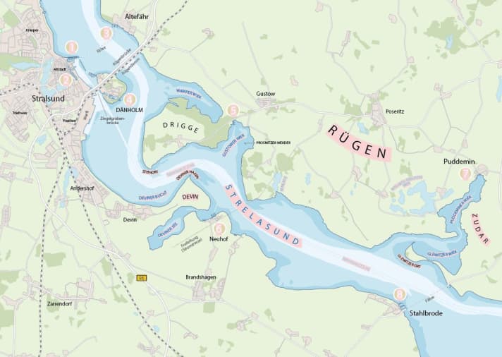
The precinct: As an arm of the Baltic Sea, the Strelasund separates the island of Rügen from the mainland of Western Pomerania. Its length between the Bessiner Haken and Palmer Ort (both on Rügen) is 30 kilometres (around 16 nautical miles), slightly less as the crow flies. With an area of 64 square kilometres, it is about half the size of the Müritz. The greatest depth is 16 metres. The only larger island is the Dänholm. The Prosnitzer Werder in second place is just 60 metres long and lies in the Gustower Wiek.
Navigation: Navigation is unproblematic by day and night. The fairway of the Strelasund is buoyed and lighted throughout, also by numerous leading and guiding lights on the banks.
Harbours and highlights in the Strelasund
1. Stralsund Citymarina
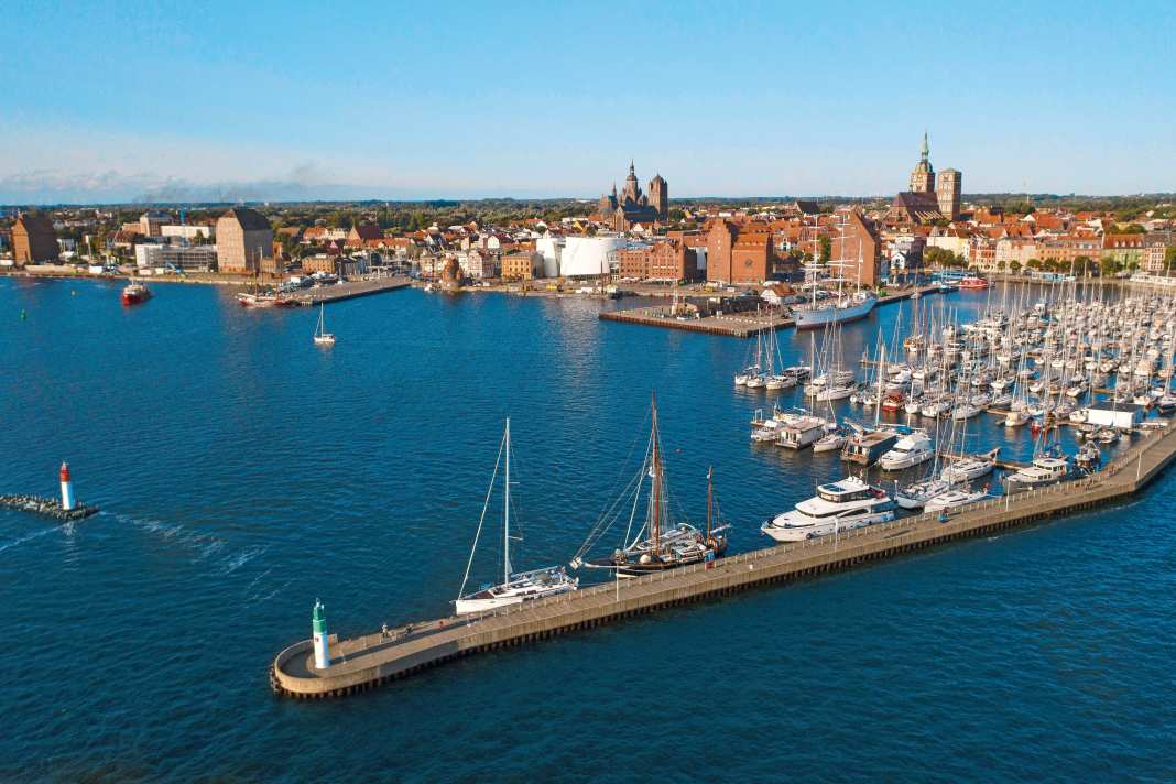
With its medieval skyline, Stralsund greets every skipper approaching the Strelasund from the Bodden waters in the north or the open Mecklenburg Bay. The massive towers of St Mary's, St Nicholas' and St Jacob's are proud witnesses to the Hanseatic era, which not only made Stralsund famous throughout the Baltic region, but above all rich. However, Stralsund is older and dates back to the Slavs, as the names of the town and estuary show: Strela means "arrow" - it can still be found in Stralsund's coat of arms. The Citymarina offers the best places (300 in total) on its floating jetties, well protected behind a long pier, naturally with electricity and water. Further information >>
2. Stralsund harbour canals
The central location in the district also ensures that the Citymarina is full in summer: Guests from Denmark, Sweden and Poland are also part of the picture. The Langenkanal and Querkanal also offer additional mooring facilities (around 30 berths). To get there, however, you have to cross movable bridges (Opening hours can be found here >>). From there, it's just a few minutes' walk to the UNESCO-listed Old Town, the Old Market Square with its cafés and restaurants or the Ozeaneum, Stralsund's spectacular aquarium.
3. Altefähr
The name says it all: until the construction of the Ziegelgrabenbrücke bridge in the 1930s, Rügen had no fixed connection to the mainland, but boats travelled from Altefähr across the Strelasund to Stralsund, transporting people, livestock and later vehicles. But even with the new bridge, things were not quiet: townspeople from the mainland now discovered the town as a seaside resort away from the hustle and bustle - with a view of the magnificent panorama of Stralsund opposite. The ferry service has now been taken over by the White Fleet. If you come on your own keel, you will find the water hiking rest area with around 50 pile boxes for guests in the western part of the municipal harbour. Further information >>
4. the Dänholm
The only island in the Strelasund is the Dänholm on Stralsund's doorstep. The name is said to come from the Vikings, who used the conveniently located island as a base for raids in earlier times. Even later, it was repeatedly the bone of contention in military conflicts: Swedes, Danes, Brandenburgers and Frenchmen came and went. The Prussians stayed and launched their naval forces here. The Dänholm Naval Museum tells the eventful story in detail. The island's position is still important today: both bridges over the Strelasund pass over it, with the older Ziegelgrabenbrücke bridge providing access to the island. There are two good starting points for pleasure craft: firstly, the jetties of the Dänholm North Water Sports Centre (250 berths, free berths are marked in green, www.wszev.de), and the basin of the former naval harbour in the south with the jetties of the Strelasund yacht club. Here, too, green indicates the free spaces. Further information >>
5 Gustow
The most scenic section of the Strelasund is about halfway along the route. Here it loops around the Drigge peninsula, which belongs to Rügen, and the Devin peninsula on the mainland side. Steep banks and coastal forests line the water, parts of the Middle Strelasund nature reserve. The moraines of the last ice age have left their mark here. The "im-jaich Naturoase Gustow" is hidden in this idyllic setting, at the inner end of the Gustower Wiek on Rügen. This includes not only 150 harbour berths on new jetties, but also a number of shore houses that can be rented for a longer stay on the island. Further information >>
6 Neuhof
Almost exactly south of Gustow, but on the mainland, is the Neuhof marina. It is the right address for crews looking for a comprehensive range of services. These include around 150 berths on floating jetties, either with pile boxes or fingers, a crane (as an option for starting a trip in the area), a boat refuelling station and technical services. There is also a restaurant - and bike hire. Because if you want to explore the surrounding area, you have to get in the saddle. You can get supplies in Sundhagen, three kilometres away. Further information >>
7. puddemin
The detour to Puddemin feels like an inland trip, as the Puddeminer Wiek, at the end of which the village in the south of Rügen lies, is as narrow as it is long: it is a good three nautical miles from the Strelasund to here. It is correspondingly quiet and sheltered. You moor in pile boxes with the bow facing the pier or jetty (inside for guests) before relaxing on the terrace of the harbour restaurant. The buoyed fairway to Puddemin has a nominal depth of 2.5 metres. Further information >>
8th Stahlbrode
The southern exit of the Strelasund is marked by the harbour of Stahlbrode on the mainland. At this last narrow point, a car ferry crosses over to Glewitz on Rügen. East of the Palmer Ort headland, the southernmost point of the island, which is only around 2.5 nautical miles away, is the Greifswald Bodden. While the northern harbour basin is otherwise reserved for clubs and the remaining fishermen, guests are accommodated on both sides of the central pier and also (together with customs) in the southern harbour. Delicious fish is available in the Molenstube or in the Fährhaus restaurant. The ferry landing stage is located at the head end of the south pier. More info>>

Nautical literature on the Strelasund:
- Cruising guide "Baltic Sea coast 2. Wismar to Szczecin" by Jan Werner. 232 p., 147 photos and illustrations, paperback, format 16.7 x 24 cm; 39.90 euros. ISBN 978-3-667-11593-5. Order here >>
- Harbour Guide "Harbour Guide Flensburg-Gdansk" by Emma Glaumann and Joakim Hermansson. 300 pp., 278 illustrations, spiral bound; € 30. ISBN 978-3-89225-720-2. Order here >>
- Recreational boating charts DK set 2 "Mecklenburg-Vorpommern to Bornholm. With Lübeck and Stettiner Haff". Edition 2022; Format: A2, single sheets in transparent bag; € 74.90. ISBN 978-3-667-12420-3. Order here >>

