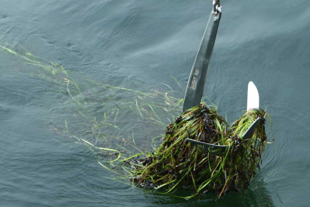


Many seagrass habitats in the world's oceans have been destroyed or are declining rapidly. A new project has therefore been launched in Sweden: Anyone travelling in the Stockholm archipelago can use their map apps to call up anchorage information on bays that are particularly worthy of protection. The initiative combines scientific data with practical applications to promote environmental awareness and the protection of marine ecosystems.
Hidden treasures under water
The Stockholm archipelago harbours sensitive biological treasures beneath its picturesque surface. Sheltered bays such as the island of Torö hide shimmering seagrass meadows - habitats for species such as the large pipefish and the broadnose pipefish. These shallow coastal strips are considered the nursery of the Baltic Sea and provide spawning grounds for fish such as pike and perch. However, careless boaters can unintentionally damage these sensitive ecosystems.
Research shows danger from recreational craft
Sofia Wikström, marine ecologist at the Baltic Sea Centre at Stockholm University, explains: "Studies from other parts of the world, for example from the Mediterranean or the coasts of the USA, show that seagrass is under considerable threat from recreational boats. Their anchors and the turbulence caused by the propellers leave permanent scars on the seabed." These findings prompted the researchers to investigate the situation in the Baltic Sea in more detail.
Sensitive ecosystems at risk
Research shows that bays protected from waves are particularly susceptible to damage. In shallow areas below a depth of two metres, the ecosystems are poorly equipped to cope with strong water movements. Boat traffic stirs up fine sediment, clouds the water and hinders plant photosynthesis. Anchors and propellers can uproot aquatic plants or bury them under stirred-up sediment. Wikström emphasises: "If a meadow is damaged, the seabed can erode, leading to further damage. Here in this part of the Baltic Sea, seagrass is at the edge of its range and has difficulty reproducing sexually." It therefore takes a very long time for seagrass meadows to regenerate.
Innovative app solution for skippers
To mitigate the impact of boating, researchers at Stockholm University have developed an innovative solution in collaboration with the County Administrative Board and the Swedish Recreational Craft Association. In co-operation with a leading developer of nautical chart apps, special digital overlays have been created. These enable sailors to display areas in a bay that are worthy of protection directly on their conventional navigation chart.
Detailed information
When sailors approach a marked area, the app prompts them to click on Details. The overlays show which plants cover the seabed and provide instructions on how to navigate the area in an environmentally friendly manner. Recommendations include low speeds, straight courses to avoid stirring up sediment and advice on suitable anchor depths. Sofia Wikström explains: "A ban would be difficult to enforce. Providing information, on the other hand, enables boaters to make informed decisions themselves."

Positive response
The free map service launched in spring has met with a positive response. According to app developer Skippo, 70 per cent of users surveyed find the information on sensitive underwater areas valuable or very valuable. Sailors like Anton Kalland regularly use the environmental information: "I want to anchor without damaging the seabed. The maps help me to recognise sensitive areas."

Expansion of the project planned
The nautical chart project currently covers around one hundred locations in the Stockholm archipelago. The aim is to map the entire Swedish coast, focussing on the most valuable ecosystems. Sofia Wikström sees potential for international cooperation: "There have long been pan-European mapping projects that compile map data from all European seas. If the EU Commission considers this important enough, it could have environmental data included in these works."
A role model for other countries
Martin Wahl, marine ecologist at the Geomar Helmholtz Centre for Ocean Research in Kiel, believes it would be promising to take similar initiatives in Germany. He emphasises: "We need to talk to each other more. Our research is focussed on publications and not on practical applications." Wahl is confident that sailors would use the environmental data if it were available. "Most of the damage is caused by ignorance, not ill will," he explains.

6 behavioural tips
Sensitive bays are often naturally sheltered from the waves, with narrow or multiple entrances, sometimes with an island to keep the waves out. If it is wavy outside the bay but glassy inside, it is probably a sensitive area.
- Enter slowly and avoid excessive manoeuvres with your boat.
- Avoid anchoring in seagrass beds.
- Use a mooring buoy if one is available.
- When anchoring, choose deep areas. The seaweed in the Stockholm archipelago grows at a maximum depth of nine metres.
- Do not drag the anchor across the seabed when hoisting. Pick it up as vertically as possible.
- Do not discharge any waste water into bodies of water. This harms the environment and is also prohibited.

