

- Read part 2 of the travel story: The English Channel - Into the blue
We're finally due to start today - even though a week has already passed. A week with beautiful summer weather, actually perfect. But a defect tied our "Rolling Swiss 2" to her berth in Sutton Harbour Marina: a cooling water pump had given up the ghost with the previous crew. Until the quickly ordered replacement part could be delivered and installed, the first half of our summer cruise with the Cruising Club of Switzerland passed in an unusual way for us - stranded in Plymouth in the south-west of England. Our destination is still the Channel Islands on the other side of the English Channel, England's famous outposts just off the French coast. However, we have already cut the programme down considerably.
Plymouth steeped in history
But now our time is up in this seafaring city that we already know far too well: From the stone waterfront of the old harbour with its white yachts and rusty trawlers, past the "Mayflower Steps", where the Pilgrim Fathers set sail for the New World in 1620, up to the Citadel and the "Hoe", Plymouth's public park, high above the shore cliffs. Legend has it that Sir Francis Drake, Vice Admiral to the first Queen Elizabeth, was bowling here in 1588 when he was informed of the imminent approach of the Spanish Armada. However, the explorer and occasional pirate took the opportunity to finish the game in peace before setting sail with his fleet to destroy the attackers. On to the Grand Parade, the waterfront promenade, to the "Tinside Lido". The semi-circular shape of the Art Deco outdoor pool was simply built into the sea. Tempting on a day like today. But we have other plans.
Ready to cast off! It's about 85 nautical miles from Plymouth in a south-easterly direction across the Channel to St Peter Port on Guernsey, which we want to call at around high tide because of the harbour traffic jam. There won't be much to see. We will also avoid the large traffic separation scheme "Off Casquets" further east on this course. We wait for the oncoming traffic at the harbour lock and then the green light is given. In bright sunshine, we sail through the Eastern Channel past the long breakwater and out onto Plymouth Sound. A weekend atmosphere on the water, even on Friday morning. However, we are aware of the weather conditions: after a few days, the wind, which has been so lacklustre recently, has shifted from west to north-east and has picked up noticeably. We still don't feel any of the four to five Beaufort in the land shield, but what will it look like further out?
Change of course to Cornwall
At least the start goes well. Blue sea all around, steep coast to the left. Fields and pastures stretch right up to the edge. Our Trader 42 works its way south-east for two hours. The flag with the Swiss cross on the stern flies freely to starboard. To the north we pass the mouth of the River Yealm, then Bigbury Bay and finally the sharp profile of Bolt Head appears ahead. The moment of truth is approaching! The few sailing yachts on our course are already pitching mightily under double reef, although the last stretch to Prawle Point is still protected by the coast. Then England ends - and we feel the full force of the wind: a staccato of hard waves. Their crests come in from the north-east over the entire length of Lyme Bay. Almost 50 nautical miles to get underway.
The direction of the sea could not be less favourable for us: It hits our hull only slightly more forward than from port abeam. The yacht starts to roll. We wedge ourselves into our seats as best we can. When the swinging becomes too wild, we lean slightly from 130 to 115 degrees. This makes the movements more bearable, but it doesn't help us either, as this course takes us too far to the east - straight towards the traffic separation scheme, which we would never be able to cross correctly.
Apart from that: Eight more hours like this? There's a huge clatter downstairs as the cutlery drawer flies open and spreads its contents across the lounge floor. There's only one choice: turn round. At least we now have the still quite rough sea from behind as we head back towards Plymouth for the first two hours. It goes without saying that staying there again is out of the question. And if we can't go east, the only option is west: Cornwall.
We quickly agree that it could be worse. After all, the Cornish coast, our new destination for the next few days, is one of the most attractive on the British Isles. The Channel crossing is postponed. It is now 275 degrees. As we pass Whitsand Bay, to our astonishment, the wind dies down more and more and finally falls asleep completely. The oily water surface is now almost smooth. We are not fooled: with its many peninsulas and capes, this sea area is notorious for the fact that the local weather under the coast can vary considerably.
Striped dolphins provide the first wildlife experience of the day; there are probably two to three dozen of them crossing our course, playing with our bow wave for a quarter of an hour and even travelling faster than us on their backs. You can clearly hear the whistling of their blowholes as they breathe over the water.
River Fowey
With the towering red and white beacon of Gribbin Head ahead of us, we soon enter the River Fowey at St Catharines Point. It is a wide and shallow river delta that branches out inland in many places. On the right is the small fishing village of Polruan, on the left Fowey itself, with white houses lined up on the riverbanks offering sweeping views. Sailing yachts, motor cruisers and fishing boats hang in long rows from their moorings, gently swaying in the current. The "King of Prussia" shines pink on the pier: our cruising guide reveals that the inn is named after a local privateer and smuggler who liked to confuse victims and pursuers with the Prussian flag. Or that the enterprising skipper looked like Frederick the Great.
We get a place alongside the guest pontoon in front of the densely wooded eastern shore, directly opposite the lifeboat station. Several historic lifeboats are moored there; we later learn that a veterans' reunion was held here last weekend. Almost all of them are now used as houseboats. To the north, before the next loop, an old chain ferry crosses the river.
Cooling desired
The heat is high above the water as we get the dinghy ready as quickly as possible and cross over. We give way to a lumbering dredger and the Harbour Taxi, which shoots past with a high bow wave. From the jetty for the dinghies, we stroll along Fore Street to Town Quai. Everything is full of visitors; the narrow streets as well as the small parks. Shade is worth a lot today. Those who are still sitting in the sun cool off with Pimm's, locally brewed "Korev" or ice cream with clotted cream and fudge. You can hear the calorie bombs hitting!
The rest of Fowey's pubs also have something to do with ships: Wooden signs and gold lettering lure you into the "Ship Inn", the "Galeon Inn", and the "Lugger". Small shops selling fashion, books and souvenirs flank the alleyways. And then there are the bakeries: Cornish pasties and French pastries are piled up on silver trays: food for your soul! In the end, we end up at the "Lugger", where the landlady looks like the Queen - much more fitting than "olle Fritz"...
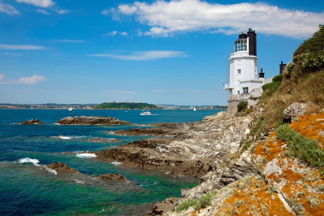
Shortly before midday, we set sail to the uninterrupted ringing of bells. The sea remains calm, but the sky is covered with a white veil. St Austell Bay, Mevagissey Bay and Dodman Point remain to starboard. The cliffs here are less imposing but still largely continuous, with small holiday resorts and individual houses punctuating the sandy brown of the coast. Then comes Falmouth Bay with the white lighthouse of St. Anthony Head, the grey walls of Pendennis Castle and the town behind it. But Falmouth is not on the agenda until tomorrow.
Helford River
Today we continue a few nautical miles further to the Helford River, one of the most beautiful spots on the south coast of Cornwall according to the cruising guide. We even find a large, green mooring buoy, but we first have to get the float and line up to the rusty chain on deck before we can pull our lines through. We have slack water, but soon the bow of the "RS 2" turns seawards to meet the coming tide.
A quick beer, then into the dinghy and to the pebble beach in front of the "Ferry Boat Inn" at Helford Passage on the north shore, the meeting place for yachties here, as I've heard. The dinghy mooring at the small floating jetty is only available for five pounds. Not particularly inviting. We save ourselves the trouble and tow our boat far up the shell-strewn beach. There's enough time to take a quick look around. White walls, few houses, fields all around. The small kiosk on the promenade sells peppermint ice cream and SUP boards for hire. The Ferry Boat Inn (the passenger ferry that gave it its name still exists) is almost empty. There are hardly any tables even on the terrace. No sign of the boat crews who are supposed to flock here in droves. After all, it's the height of summer!
The South West Coast Trail, a popular long-distance hiking trail, runs right through the village. We follow it along the cliff edge, past peacefully grazing cows and through dark hollow paths for longer than planned, until we reach a point with a good view over the bay: Now more and more yachts are arriving - a string of pearls that stretches out into the bay in a gentle arc. Back at the bottom, the first beer-thirsty crews are actually streaming towards us. And our dinghy is still a metre away from the water's edge. Good timing!
Off to Falmouth
The next day, it's just "round the corner" to Falmouth, less than ten nautical miles, so not worth mentioning in nautical terms. As we enter the harbour, we pass a couple of grey giants: Royal Navy transporters. In the Port Pendennis Marina, we are only lucky to find a place in the packet, partly because a gigantic high-tech ketch from Bermuda alone takes up at least five berths on the guest jetty. On the other hand, the National Maritime Museum of Cornwall is located right next to the harbour. Inside, a lot revolves around the specialised boat building of this region, such as pilot gigs and quay punts. Both types were designed with speed in mind, rowed pilot boats on the one hand and sailed cargo tenders on the other. In both cases, the rule was: whoever reached an incoming ship first had the job!
Time to turn back: the wind is shifting and we still have to cross the Channel in the next few days. So we head back east to find a good jumping-off harbour for the crossing from Cornwall to France. From St Anthony Head the next day, we set our sights on the Eddystone Rocks on an E course. The wind is already in the south-west and initially allows us to roll quite a bit. This goes on for three hours, with the autopilot pointing 095° to the hazy east. But it doesn't take long before the famous lighthouse becomes visible ahead.
We are already thinking about how close we want to pass when a vessel approaches us from starboard. Slender silhouette, high mast, no AIS and an impressive bow wave. The coastguard? We stubbornly steer straight ahead until the other boat actually comes up from astern in a wide arc and almost catches up with us. Then it crackles on the radio: "Rolling Swiss 2, this is Border Force Vessel 'Vigilant', over". They have us on the hook, and so close to our destination - the lighthouse - we have to follow the border guards south towards Cawsand Bay near Plymouth. Once again. Not at a ruinous 15 knots, but only at an economical 8 knots, but our plan to continue on to Salcombe has been cancelled. Anyway! We pull into the wake of the grey boat.
We finally reach the bay where Morten and I stopped by on the excursion ferry in bright sunshine on the very first weekend. The "Vigilant" drops anchor and we go alongside with our own lines. Two officers climb over, friendly and correct. The skipper comes down several times to check that everything is in order. Passport control, proof of VAT and a few glances in the lockers in the saloon. Instead of contraband, only English oat biscuits. That's it. The departing "Vigilant" leaves us rolling in her stern sea. And we just stay where we are: Cawsand seems to be a real pearl in Cornwall - which we probably wouldn't have stumbled across without the friendly "help" of the Border Force.
Precinct information

Cruising stages in Cornwall
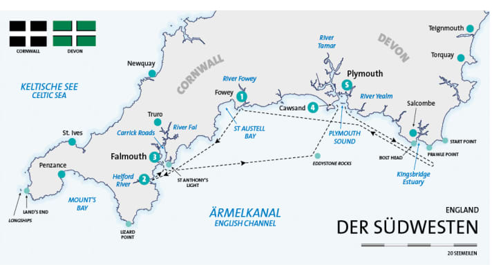
S Plymouth - Fowey (via Prawle Head): 70 nm
- Fowey - Helford Passage: 25 nm
- Helford Passage - Falmouth: 8 nm
- Falmouth - Cawsand Bay (via Eddystone Rocks): 43 nm
- Cawsand Bay
Total distance (first half of the trip): 146 nm
Literature
Recreational craft chart sets: SC 5602 "The West Country. Falmouth to Teignmouth" and SC 5603 "Falmouth to Hartland Point. Including the Isles of Scilly". British Admiralty: A2, price: €72.20 each. www.hansenautic.de
Harbour and area manual: "West Country Cruising Companion" by Mark Fishwick. Fernhurst: 272 pages, A4 format, hardback, ISBN 978-1-909911-08-6, price: €49.80. Order via www.hansenautic.de
Tip
The next high tide is sure to come! Knowing the exact course of the tide can be crucial. For example, if you land the dinghy on a beach when the water is rising. Carry the boat to above the high water mark.
Our harbours
Registration is standard practice in Cornwall. Moorings and murings are allocated by radio or telephone. Plymouth Sutton Harbour Marina, www.suttonharbourmarina.com ▪ Fowey: Fowey Harbour, www.foweyharbour.co.uk ▪ Helford Passage: Helford River Moorings, www.helfordrivermoorings.co.uk ▪ Falmouth: Port Pendennis Marina, www.portpendennis.com ▪ Cawsand: Cawsand Bay Anchorage
Weather/climate

The club
We travelled the English Channel with the Cruising Club of Switzerland (CCS). With around 6,500 members, the Bern-based Central Club is one of the largest water sports clubs in Switzerland and is a leader in deep-sea training for pleasure craft. The motorboat division forms its own subdivision within the club with its own yacht, which is used for training and travelling trips in northern and western Europe. www.ccs-motoryacht.ch
Our boat
Type: Trader 42 (GRP semi-planing) - Length: 13.30 m - Width: 4.30 m - Height: 3.80 m - Draft: 1.20 m - Berths: 6 (3 double cabins) - WC/shower: 2/2 - CE category: A - Motorisation: 2 x 380 hp - Special equipment: VHF radio system, plotter with radar and AIS overlay, generator, EPIRB, dinghy
Driving licence
Skippers on their own keel and with a German residence require an official recreational craft licence with the scope of validity Sea.
The precinct
The south-west coast of England stretches for around 160 kilometres as the crow flies from Portland Bill in the east to Land's End in the west. The coastline is characterised by wide, crescent-shaped bays, divided by two headlands: Start Point and Lizard Point. These peninsulas protrude into the English Channel like oversized groynes and are responsible for challenging tides and local weather deviations.
The coastline itself is characterised by rocky cliffs, sandy beaches and widely branching estuary deltas. These so-called rias are glacial estuaries that are now submerged and bear no relation to the rivers in the hinterland. The sheltered water areas on the inside of the barre and the arms leading further out form natural harbours that are used for buoy fields. Although some towns offer public moorings, these are usually only intended for a small number of boats. This is better in the commercial marinas, which are all of a high standard. Navigation requires experience and good seamanship, especially when travelling in the area. Precise trip planning is mandatory. Collision avoidance rules apply, buoyage and fairway lighting are sufficient. VHF radio communication is common. Sea rescue: rnli.org

