

The fresh sea breeze works wonders as we get out of the car park at Marina De Batterij. Six hours on the motorway behind us, we have now arrived in Willemstad in the south of the Netherlands. It's mid-June and the coronavirus actually seems to be taking a break. An opportunity that we want to use to get to know a new corner of our neighbouring country on our own keel - the province of Zeeland. The name says it all: "Sealand". The sea is, of course, the nearby North Sea, but apart from that, there is water in every direction you look anyway.
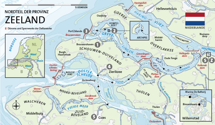
Later, during the briefing on board our Linssen Grand Sturdy 45.0 AC, Paul-Michiel and Maasje from Dutch Yacht Rentals tell us what awaits our small crew over the next week: the lagoon-like Grevelingen with its artificial islets, a trip to the North Sea beach, then the Oosterschelde, where the tides continue to set the pace, and finally the lively old trading town of Goes. A full programme in any case in this area behind the sea.
Eb en vloed: The changing tides have long ceased to rule the entire region
The next morning, we leave De Batterij and end up in rush-hour traffic on the Hollands Diep, one of the estuaries of the Rhine. The "Toronto" approaches from the right and the "Jabo" from the left. We cross the fairway after the freighters have passed and follow the buoy line to the outer harbour of the Volkerak Jachtensluis. It is huge - and yet no comparison to the more than 300 metre long twin chambers for large ships next door. As soon as we moor at the waiting jetty, the traffic lights turn green. After pulling in, we lie in the shade of the motorway bridge above us. But it's only a few centimetres down to the valley, a levelling out, that's all. The huge structure is primarily used for flood protection: it is part of the Delta Works, an artificial bulwark against the fury of the North Sea.
The decision to build was made in 1955, triggered by the devastating Dutch storm surge two years earlier. This largest natural disaster of its kind had cost the lives of almost 2000 people in the Netherlands, especially here in the south, in Zeeland. A monumental staggered protection system was planned, with the first line of defence being provided by dams and barrages: they would close off the three inland bays of the Haringvliet, the Grevelingen and the Oosterschelde, creating a closed coastline from Rotterdam to the Westerschelde. Millions and millions of cubic metres of sand and concrete were used and billions of guilders invested. The last gap was closed in 1997. Today, the Delta Works, together with the Panama Canal and the Eurotunnel, are among the seven wonders of the architectural world. But protection also has its downsides: Changes in the flow behaviour, salt and oxygen content of the separated waters have led to serious ecological problems that continue to concern society, business and politics in the region.
Zoet en zout: Sweet water on one side, salty on the other
To the west runs the wide Volkerak, to the north lies the island of Goeree-Overflakkee with green dyke lines and wind turbines, the occasional avenue and a church tower in the distance. Sailors cross the fairway to the north-west. In the early afternoon we reach the Krammersluizen outer harbour in Philipsdam. There are even two chambers for pleasure craft, so the crowds are already a little bigger. Salt and fresh water meet at the dam and are kept strictly separate for ecological reasons. The water requirements of the chambers are therefore regulated via reservoirs, which takes some time. And we cross yet another border here: In keeping with the salty water, the province of Zeeland begins.
The journey through the tidal area takes just half an hour, then it's time for the last lock of the day. The Grevelingensluis at Bruinisse, the only gateway to the Grevelingen. There's a lot going on here! A good two dozen boats are already bustling about in the waiting area and on the jetties. We go into a large Windy Chinook and ask the friendly neighbour about the order. "All at once," is the answer. The lock opens - and even more boats rush out from inside. But there is no sign of chaos. Not even when the people waiting for their turn come off and enter. Everyone has an eye on everyone else and a helping hand.
Tranquil Grevelingen
The Grevelingen, or Grevelingenmeer, as the centre of the three separated former North Sea bays is also known, is now the largest inland saltwater lake in Europe. The dyke disappears into the hazy distance. We see Mosselbank, the first of the artificial islands that were also created for recreation on the water. We count around two dozen masts on the jetties and many anchored boats. Two jet skis speed past. However, we stay below the coast of Schouwen-Duiveland and follow the fairway to the north-west until we finally reach the entrance to Brouwershaven.
We are called by loudspeaker in front of the open lock. Our colleague René climbs over, registers us, and less than ten minutes later we are moored at the new jetty in the very centre of Oude Haven. The place makes a cosy impression, with restaurants and cafés in old captain's houses all around, plus the carillon from the radhuis on the market square. After a lovely meal at the Swarte Schaep on the Zuidzijde harbour, we take a few more steps along the top of the dyke in the last light. The Grevelingen waits quietly for the night. The wind has already fallen asleep.
By chance in the South Seas
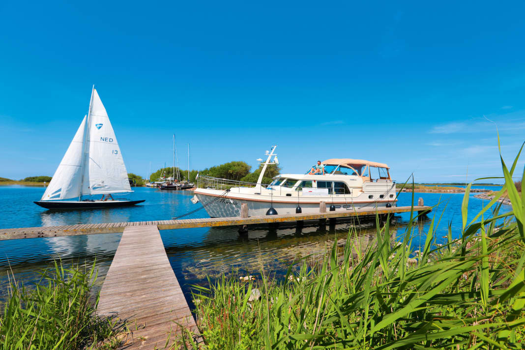
Blue skies the following day. We take our time, because we don't have far to go: our destination for the day is Archipel, the smallest but supposedly also the most beautiful of the artificial islands, less than five kilometres from Brouwershaven as the crow flies. After a short round trip across the widest part of the Grevelingenmeer, past the islands of Ossehoek and Hompelvoet, we approach from the north. A few mastheads can already be seen above the bushes and trees. We round the island and enter the lagoon; on the main island with its "beach" and "jungle", all the places are already taken, so we moor up on the small neighbouring island: its wooden T-jetty is big enough for three boats, the shore leave ends after two metres in the thicket: a nature reserve! We are allowed to stay for three days. The water is surprisingly clear and offers a view of the stone blocks that form the artificial bank stabilisation.
Our small community consists of just under a dozen boats, sailors and a few motor yachts. All of them have the brown pennant of the Staatsbosbeheer hanging from the mast, indicating that the licence fee for the jetties in Grevelingen has been paid. Awnings are stretched over cockpits, people are paddling and even swimming. But in the late afternoon, an astonishing calm returns, with only leaves rustling in the light wind, which rises again much later than expected. Nowhere in Zeeland is more like the South Seas.
Southern French flair in Zeeland
A day could hardly start more peacefully than with sunshine over the shimmering lagoon. As close as the North Sea is, it seems so far away at this moment. We move to the large island, whose jetty has emptied out, and make breakfast into a picnic. Sandy paths lead through dense bush to the beach, where we spread out our blanket. Once again, we only have a short hop ahead of us, over to Port Zélande, our third - and last - stage destination in Grevelingen. Just under three quarters of an hour later, we reach this destination too, register by phone and get a pitch right on the havenkantoor. The site is modelled on Port Grimaud in the south of France, the harbour settlement planned on the drawing board in the 1960s, hence the French version Zélande instead of Zeeland. Next door in the holiday village, pastel-coloured modular houses stand between pine trees, one unit like the other.
But we want to get to the beach anyway - and it's on the other side of the Brouwersdam, which separates the Grevelingenmeer from the North Sea. Swimming is the order of the day - after all, it's already the middle of June! A pedestrian bridge takes us over the motorway to the fully asphalted dyke. Then comes the actual dune belt and finally the beach, an endlessly wide plateau, as if swept clean. Campers and a few motorhomes gather at the few buildings, high-legged wooden constructions. A kite school and three restaurants are within sight. Kites are in the sky. The wind, about three Beaufort from the northwest, is almost cool, the sea a real grey. Still the South Sea in the morning, now the North Sea! Jumping into the waves certainly awakens the spirits.
We return later for a visit to Natural High, one of the beach cafés with a view. As grey clouds gather on the horizon over the open sea, we sit sheltered from the wind and let our minds wander. As if in a dream, the gloomy towers of cloud finally pass us by and leave the stage to the setting sun.
Off to Zierikzee
After three days in the lagoon, it's time for tides: Zierikzee is the next destination, a harbour with high and low tides in the south of Schouwen-Duiveland, on the Oosterschelde, which has also been tamed by the Delta Works but is still tide-dependent. At Grevelingensluis, we are the only boat on the jetty this time. Although there are two more sailors, there is no sign of the weekend crowds. The fact that the chamber is nevertheless full is due to two mussel cutters, large ships of around 30 metres, which steam around the corner shortly before closing time.
The Grevelingen is history. The sections of the wide delta arm on which we travel to the south-west have their own names: Zijpe, Mastgat, Keten. Schouwen-Duiveland is still on the right, Sint Philipsland and Tholen on the left. Dikes and wind turbines again, the flat polders behind them remain invisible. As we are travelling just before high tide, the sands are also covered and there is no sign of the extensive Vondelingsplaat.
The white line of the Zeelandsbrug has been visible for some time as we round Hoek van Ouwerkskerk. You can feel the wave a little now. However, we quickly reach the bridge, pass through the main passage and are standing in front of the Zierikzee harbour canal at half past two. A massive church tower, which we initially think is a warehouse, and a windmill rise up behind the dyke. After we pass the open sea lock, things get exciting: we have forgotten to reserve a berth, but when we round the last bend to Nieuwe Haven after two kilometres, half the jetty is still free - and the harbour master is already cycling up in his fresh uniform shirt to help us moor. We turn the bow seawards and are soon moored. Now, at high tide, we even have the best view of the waterfront promenade, holidaymakers, day trippers and inviting terraces under parasols.
Where is de Gekroonde Suikerbiet?
Further along the quay, there are fishermen, flat-bottomed boats and dressed-up aaken, and the first parcels are already forming at the pedestrian walkway. We walk through pretty alleyways to the market and on to the imposing monstertoren (the church tower, visible from afar and dominating everything; the word actually means "cathedral", although "monster" would not be inappropriate either ...). We return to the boat via the inner harbour and the historic harbour gate with its white wooden bascule bridge. De Gekroonde Suikerbiet is just a few steps away. We don't find "crowned sugar beet" on the menu, but we do find mussels in beer sauce and burgers à la Hatuna Matata - with tuna. Simply heerlijk!
The following morning is the hottest yet. However, the wind picks up, which prompts us to have breakfast at the mooring rather than underway. However, the tide is low and we can only see the green wall, even from the stern. As we cast off, the next day guests are already waiting impatiently. It's actually a bit fresher outside, probably three Beaufort from the west. It's quite choppy over the bar of the harbour canal, but soon we're in calm water and on our way south to Goes: the old trading town is located on the Zuid-Beveland peninsula, which separates the Oosterschelde and Westerschelde, and was highly recommended to us when we took over the boat. After passing the Zeelandsbrug again, we therefore follow the fairway with the tidal current in a southerly direction, with the coast of Noord-Beveland and the entrance to the Veerse Meer on the right and the Galgeplaat on the left.
And suddenly Zeeland feels like the Mediterranean
Just under two hours after setting off, we approach the Goese Sas, where the five-kilometre-long harbour canal to Goes begins, and slip into the lock behind a sailing yacht that has just arrived. Now we even come to a real piece of inland waterway, with trees on the banks, waving cyclists and a total of three bascule bridges that open for us. The last one - after a housing estate with an artificial lake and elegant new buildings directly on the canal - clears the way into the city harbour of Goes.
We find a nice spot alongside the Grote Kade and are amazed once again: in the backlight of the bright sun, Goes looks very much like the Mediterranean, despite the stepped gables. The same applies to the market square, where the tower of the Stadthuis casts a long shadow on the pavement. The restaurants on the east side are open and almost all the tables are occupied by young people. Scooters rattle past, it's loud. See and be seen!
The end of the song
We have seen Zeeland and got to know some beautiful places. But our charter week is coming to an end, and the only thing left for us to do is head back northwards - via now familiar territory. We get through so well that we decide to spend the last night at least in the inland harbour of Willemstad. At the very back of the harbour, by the windmill in front of the dyke, there is exactly one place left for our Linssen.
Willemstad is also exceptional; the accurate grid of its cobbled streets lies within the preserved moats of a star-shaped fortress. City founder Prins Maurits van Oranje commissioned the renowned Alkmaar architect Adriaen Anthonisz to build the exemplary defence system at the end of the 16th century. But the warlike atmosphere has long since been left behind and today serenity reigns. Flowers bloom everywhere. In this historical context, the Anno 1610 also fits perfectly into the picture, on whose open-air veranda we raise our glasses to Zeeland and the south. Another balmy summer night here, behind the sea! The landlord comes to our table and asks if we'd rather come inside with our bottles of Willemsch: "There's a bit of a storm coming in from the North Sea," he says, winking at us.
Service

Cruising stages
SWillemstad-Brouwershaven: 24 nm
- Brouwershaven archipelago: 5 nm
- Archipelago-Port Zélande: 4 nm
- Port Zélande-Zierikzee: 23 nm
- Zierikzee-Goes: 11 nm
- Goes-Willemstad: 30 nm
Z Willemstad
Total distance:97 sm
Literature
Cruising guide "Holland 1. Zeeland and the southern provinces" by Jan Werner. 5th ed. 2020, 224 pp., 113 illustrations, format 24 x 16.6 cm, paperback; 34.90 euros. ISBN 978-3-667-11747-2. www.delius-klasing.de
ANWB water maps "13: West Brabant" (ISBN 978-9-01804-608-8) and "14: Zeeuwse Delta" (ISBN 978-9-01804-609-5), edition 2020, folding map, scale 1:50 000; 16.95 euros each. www.hansenautic.de
The TOP 3 in the district
- Zierikzee Pure Zeeland: a pretty harbour and a varied town with the best supply options behind it. Plus a magnificent view from the tower of the former Sint-Lievens Minster over Zierikzee and the Oosterschelde
- Port Zélande There is no need to disagree about the beauty of the resort itself. However, the moorings, range of services and, above all, the location are excellent: the North Sea beach with its dunes and beach cafés is on the other side of the Brouwersdam
- Goes Nowhere else in the region is it livelier than here. Goes is a youthful centre of attraction for the entire region. The small museum De Bevelanden provides information about traditional life and the eventful history of the area, which has been shaped by the sea

OUR BOAT: Linssen Grand Sturdy 45.0 AC - Length: 13.98 m - Width: 4.35 m - Draught: 1.20 m - Height: 2.95 m - Cruising speed: 7 knots - Motorisation: 2 x 110 hp - Bow and stern thruster - Stabiliser - Plotter - Hot-air heating/air conditioning - Electric cooker, oven, microwave - Cabins: 3 (double berths) - Heads: 2 (WC, shower) - Weekly rates: 3195 to 4795 euros.
CHARTER:We were travelling on a boat from Dutch Yacht Rentals. The company, which is also part of the Linssen Boating Holidays network, is based in Marina De Batterij in Willemstad in the province of Noord Brabant. From there, trips are possible to completely different regions, for example to Zeeland (as described here), but also to the north towards Rotterdam and Dordrecht or to De Biesbosch National Park.
The fleet includes very well-equipped Linssen steel yachts for two to eight people. Contact: Dutch Yacht Rentals, Lantaarndijk 6, NL-4797 SP Willemstad, tel. +31 (0) 168-22 60 04. www.dutchyachtrentals.de
Weather/climate

Nautical information
The precinct: The province of Zeeland is the most south-westerly of the Netherlands and, in addition to islands and peninsulas, consists of the exclave of Zeeuws Flanderen, surrounded by Belgium and located south of the Westerschelde, which can only be reached directly from the rest of the Netherlands by road tunnel. The area is also characterised by water, with all waters being completely open to the North Sea and subject to the tides until the Delta Works were built. From north to south, these are Grevelingen (closed off and without tides), Oosterschelde (closed off but with tides) and the still open Westerschelde, which also provides access to the harbour of Antwerp.
On the inland side, all three bodies of water are also connected via the continuous waterways of the Rhine-Meuse Delta, on which there is a high volume of inland shipping traffic. The nautical infrastructure is correspondingly extensive, with buoyage and lighting available throughout. Particularly in the tidal areas, even recreational skippers should familiarise themselves with the fairways, and nautical charts must be up to date. The "Wateralmanak 1" and the "Binnenvaartpolitiereglement" (BPR) in the currently valid version are also mandatory equipment on board. Further regulations can be found in the nautical literature.

