

Summer in south-west Sweden is not over yet: In the first part of the area portrait, we followed the shores of the Öresund from the beaches of the Falsterbo peninsula via holiday resorts and fishing villages, harbour by harbour, to the metropolis of Malmö and beyond. Now it's the turn of the northern half - because it too offers boaters a wealth of varied destinations. The journey continues!
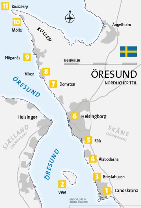
1 Landskrona
The second part of our district portrait begins with a city that was once destined for great things: Landskrona - the "Crown of the Land". Founded in 1413 by the Danish King Erik VII - the province of Skåne still belonged to Denmark at the time - it was to become the new political centre. And not only Denmark belonged to it: since 1397, all three Nordic kingdoms were united under the banner of the Kalmar Union, including Sweden and Norway. This union lasted until 1523, which was unique in the history of Scandinavia. However, the king quickly lost interest in Landskrona and moved back to the other side of the Öresund to Copenhagen.
The strategic importance of the site remained, however, and so in the sixteenth century the citadel was built, whose massive red walls are reflected in the water of its star-shaped moat ( www.citadellet.com ). The building is located just inland from Lustbåthamn, home of the Landskrona Segelsällskap ( www.landskronass.se > harbour). Guests on their own keel are welcome, but can also be accommodated in Nyhamn in the centre of town or in Lundåkrahamn to the south-east (about two kilometres outside the centre) ( www.lundakrahamnen.se ). The modern three-legged water tower directly on the shore serves as a landmark for the northern approach to the city harbour.
2. island of Ven
Less than four nautical miles north-west of Landskrona lies Sweden's only island in the course of the Öresund, Ven. Just eight square kilometres in size, it consists of a plateau up to forty metres high with sandy cliffs, the Backafall. Just four hundred inhabitants are spread across the four small villages, the rest is protected nature that invites you to roam ( www.lansstyrelsen.se/skane > Search term: Vens backafall).
However, Ven is best known for an inhabitant of earlier times, who also left clear traces behind. In the sixteenth century, the Danish astronomer Tycho Brahe explored the secrets of the universe here. King Frederik II financed two observatories for him, Uraniborg and Stjärneborg, where Brahe set up his quadrants, spheres and other measuring instruments and peered into the sky for twenty years. Today, Stjärneborg has a visitor centre ( www.landskrona.se > search term: Tycho Brahe museet). The island can be visited by ferry from Landskrona ( www.ventrafiken.se ) or, of course, by boat. Three small harbours welcome guests, Norreborg in the north, Bäckviken in the east and Kyrkbacken in the west, the latter being the largest ( www.kyrkbacken.se ). Moorings are made in boxes, and there are a few places alongside for large boats. In summer, however, it quickly gets very crowded, especially at weekends, and those who arrive late can end up with nothing on the whole island.
3. borstahusen
Back on the Swedish mainland coast, things are much quieter. The nearest holiday resort - directly opposite Ven - is Borstahusen. The local sailing club BSS is responsible for the well-protected marina with its 280 berths ( www.borstahusens-ss.se ). In addition to a slipway, trailer parking spaces are also available here. The central point of interest at the harbour is the Pumphuset, a former pump house, which now houses an art and museum exhibition as well as a restaurant serving creative variations on the local Schoenisch cuisine ( www.pumphuset.nu ). Borstahusen beach is just north of the harbour.
4. Ålabodarna
It's Stone Age in Ålabodarna. But not in the harbour of the small holiday and fishing village itself, which is located about halfway between Landskrona and Helsingborg and has absolutely modern facilities ( alabodarna.se ). An insight into early history is possible about half a kilometre to the north. There, in the middle of a field, rises a circular mound covered in greenery: the Örenäs passage grave. The megalithic site, which is around 5000 years old but still well preserved, was built by people of the so-called Funnel Beaker Culture, who did not yet know any mechanical aids for piling up the stones, which weighed several tonnes. Keep your head down!
5. råå
This small fishing village, which now belongs to Helsingborg, takes its peculiar name from the watercourse that winds in narrow loops through its centre and flows into the Öresund (the second "Å" means river). On the south bank of the estuary is the entrance to the surprisingly large marina, Småbatshamn, which not only has over a thousand moorings on floating jetties, but also a comprehensive range of services on land and three local water sports clubs. There are also a number of moorings on the north bank of the estuary ( raahamn.se ). The Råå Museum at the harbour has a colourful, lively collection on the history of fishing and shipping on the Öresund ( raamuseum.se ). The På Piren bar-restaurant just south of the museum offers another view of the river (facebook.com > På Piren Råå).
6 Helsingborg
City planners in Helsingborg have always had to make do with little space: This is because the narrow coastal strip is bordered inland by the Landborgen, a cliff edge that rises up to forty metres. In the past, this natural defence wall was ideal for defence purposes. But in less warlike times, it was more of a hindrance - especially when it came to traffic. On the other hand, Denmark is closer to the Öresund than anywhere else. It is just four kilometres across to Helsingør, the towers of Kronborg Castle - made famous by Shakespeare's "Hamlet" - seem close enough to touch. Ferries run every half hour. But it is precisely the crowdedness that makes Helsingborg so appealing. Everything is close together here, from the ferry harbour and Sundstorget to the striking town hall and Stortorget, which is actually also a square, but thanks to the magnificent neo-classical and neo-renaissance façades, is also something like the shortest boulevard in Northern Europe.
The best example is the windowed front of the Hotel Mollberg. Terraced steps lead up from here to the castle park, in the centre of which rises the Kärnan, a fortified tower more than thirty metres high, which can be climbed ( karnan.se ). However, most of the action in summer takes place at Norra Hamnen: Helsingborg has also discovered modern living by the water. The quay promenade is lined with bars, cafés and restaurants with views of the marina and the Öresund beyond the pier. This is clearly the best place for guest moorings, either on one of the floating jetties or along the quay wall itself ( www.marinahelsingborg.se ).
7th Domsten
After Helsingborg, a city of 100,000 inhabitants, only small holiday resorts follow in the north. The first is Domsten with just 600 locals. Here too, the Båtklubb is responsible for the harbour ( domstensbatklubb.se ), and the beautiful beach starts right next door. Sometimes it doesn't have to be more than that.
8th Viken
The nearest harbour is clearly visible from the beach in Domsten: Viken, however, is somewhat larger in every respect and has more berths ( www.vikenshamn.se ), shopping facilities and restaurants. You can moor directly in front of the "Barbord" ( www.barbord.com ). Or you can pop into the Conditori Öresund on Bygatan, where you'll find much more than just sweets ( www.conditorioresund.se ).
9th Höganäs
The town and harbour are located at the base of the Kullen peninsula, the coast of which stretches from here to the north-west. Höganäs is the main town of the municipality of the same name, which covers the whole of Kullen, and the supply options are correspondingly extensive. The Höganäs Båtsellskap ( hbs.se > Hamnen).
10th Mölle
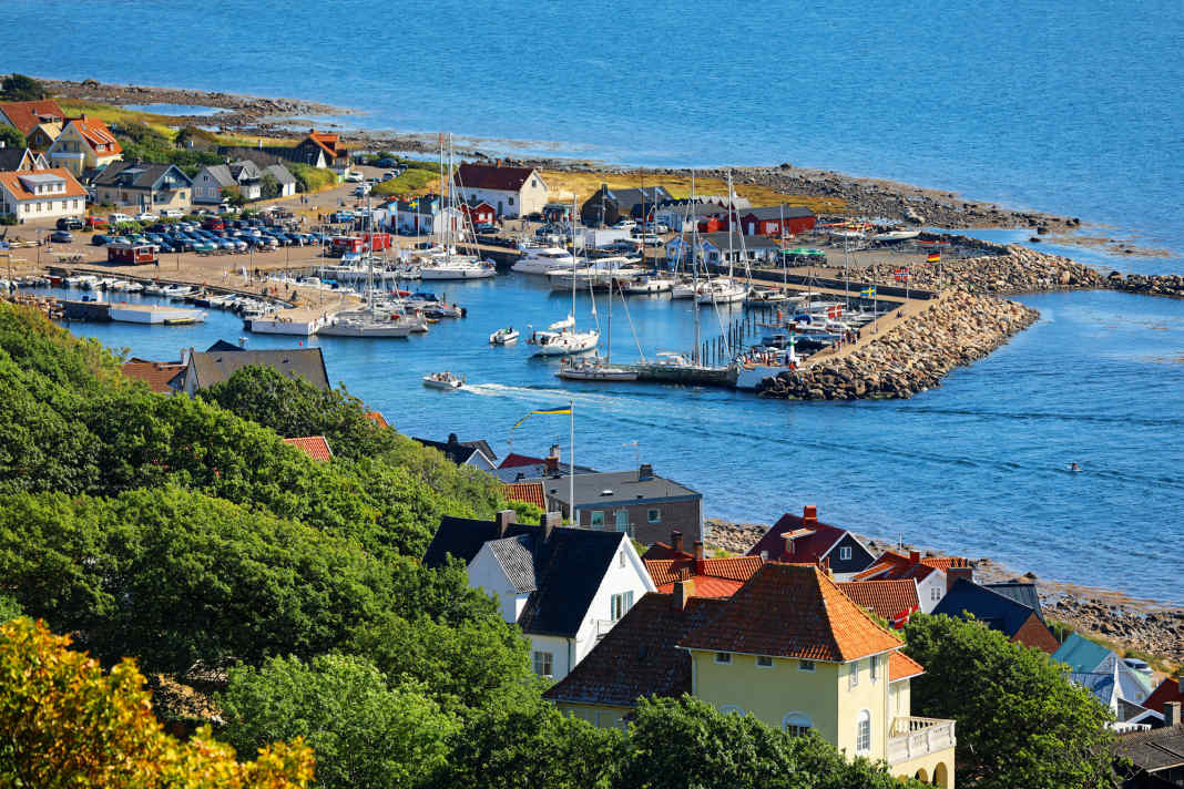
The last Swedish port of call on the Öresund is the pretty holiday resort of Mölle on the south coast of Kullen. This is where the ascent of the Kullaberg begins. The Kullen lighthouse, which marks the northern end of the Öresund and its crossing into the Kattegat, is just two nautical miles away. The pretty holiday resort, whose wooden houses gleam white against the wooded slopes, is also a popular destination for this reason. However, the harbour itself is very small, which is why thick packets at the few longside berths in the inner part of the basin are not a common sight until the evening during the season. But it is all the more atmospheric ( www.mollehamn.se ).
11th Kullaberg
At the eastern tip of Kullen, the Kullaberg - the name also stands for the entire peninsula - rises around one hundred metres above the sea. Covered in dense tree cover, including ancient beech forest, the rocky coastline slopes steeply down to the sea. The region has been designated a nature reserve and is easily accessible from Mölle ( www.kullabergsnatur.se). The Kullens Fyr lighthouse offers a magnificent view of the sea and land all around ( kullensfyr.se ). This is where the area ends and a new one follows to the north: the Kattegat.
Service

Distances
- Barsebäckshamn-Landskrona (Lustbåthamn): 8 nm
- Landskrona island Ven (Kyrkbacken): 6 nm
- Landskrona-Borstahusen: 2 nm
- Borstahusen-Ålabodarna: 3 nm
- Ålabodarna-Råå: 4 nm
- Råå-Helsingborg (Norra Hamn): 4.5 nm
- Helsingborg-Helsingør: 2.5 nm
- Helsingborg-Domsten: 5 nm
- Domsten-Viken: 2 nm
- Viken-Höganäs: 4 nm
- Höganäs-Mölle: 6 nm
The TOP 3 in the district
- Day in Mölle: A picnic with a view, typically Swedish! With the basket packed and the 202 bus from Mölle bus station to Kullens Fyr ( www.kullaleden.se )
- Evening in Helsingborg: Stroll along Stortorget, climb up to Kärnan, then relax and enjoy the evening sun on the quay promenade at Norra Hamn, perhaps in KP10 ( www.kp10.se )
- Night on Ven: Climb the cliffs and marvel at the starry sky like Tycho Brahe once did ( www.sternschnuppen-kalender.de )
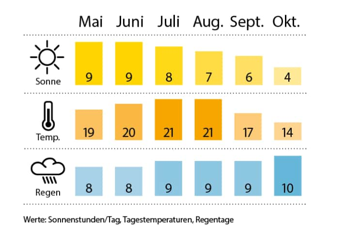
Weather/climate

SEA MAPS Delius Klasing sports boat chart set 4 "Great Belt to Bornholm". Single charts in 60 x 42 cm format (A2) in plastic pouch, 4 over-sailors, 33 area and detailed charts, area guide (108 p.) with area information and waypoint list including 60 harbour plans, with digital nautical chart for "Yacht Navigator", ISBN 978-3-667-11603-1, price: € 79.90. www.delius-klasing.de
PORT GUIDE Harbour Guide "Denmark and Southwest Sweden" by Per Hotvedt, 3rd edition (2019), with all important nautical information, aerial photos and plans of harbours and anchorages. 308 pages, 434 illustrations, format: spiral binding, 22.5 x 30 cm, ISBN 978-3-667-11346-7, price: €69.90. www.delius-klasing.de

