

Read the other parts of the travelogue about the Skagerrak:
The wind shifted to the north during the night and decreased noticeably. The old swell from yesterday is now running sluggishly towards the coast and the "Rolling Swiss 2" has been heading north-east in a straight line for two hours. Our destination is Svenner, a small group of rocky islands north of the ferry and harbour town of Larvik.
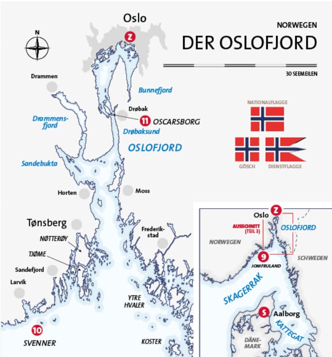
After around ten days, which took us here together with the Cruising Club of Switzerland from Aalborg in Denmark via the Kattegat and Skagerrak (see BOOTE issues 3 and 5/2018), our summer cruise is heading towards its destination: the capital of Norway. Ahead of us lies the Oslo Fjord, almost 70 nautical miles long, one of the longest fjords in the country and the busiest. Sjøveien - "the sea route". Svenner is to be our starting point.
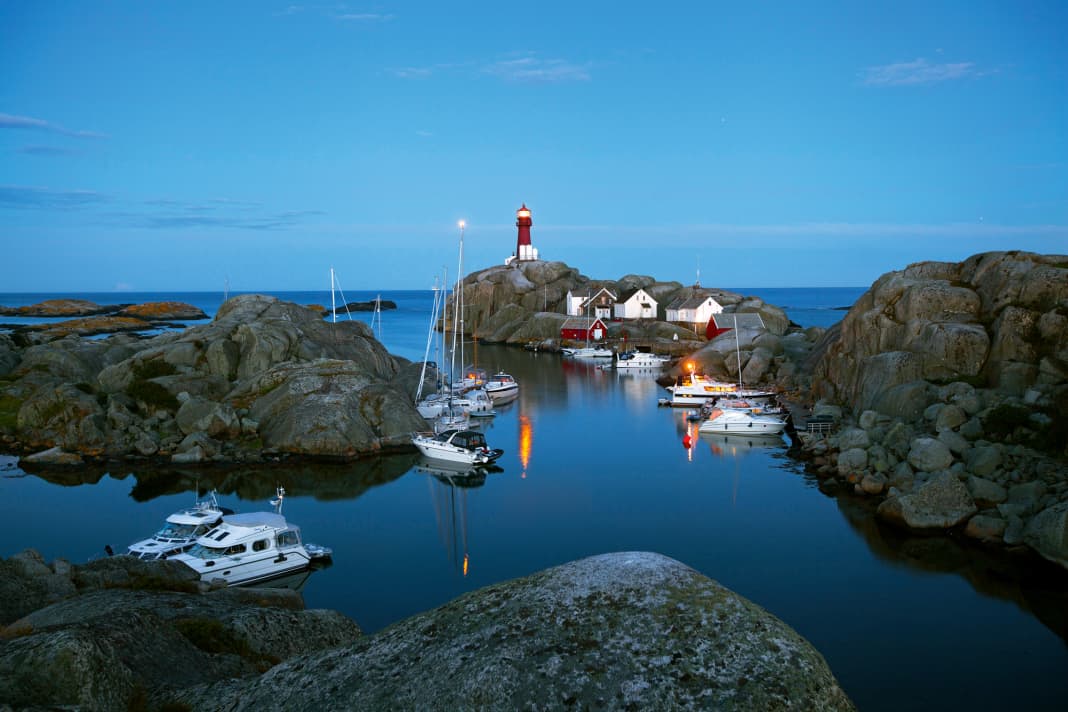
The islands have been in sight for some time, the entrance to Fyrhavna - the "harbour of fire" - is from the south and is impressive. There is still a lot of surf on the rocks, which rise high and carry the lighthouse on the port side. We are almost the first in the elongated bay. Alongside the rocks or with a stern anchor on the jetty? In the latter case, it's easier to get out, so the anchor is weighed aft and unplugged. Sandy bottom. We lay two shore lines to windward.
Svenner is very much to our taste, wild and rocky. There are three bays in total, the one in the north - the northern arch - even has a sandy beach. We set off on an exploratory tour over the rocks, Morten climbs right away and looks for the best spots for photos.
Clouds and showers alternate with sunshine, the contrast makes for a dramatic sky. The houses at the foot of the lighthouse rock used to belong to the keeper's family, today they are rustic holiday flats. In front of the shed, people sit sun-tanned in deckchairs and children fish for crabs in the clear shallow water by the small bridge. Not much grows here anymore, but in the past there was even a vegetable garden and livestock farming, as black and white photos in the small museum reveal. Stone steps and rusty railings lead further up, providing a great panoramic view, even if the rust-coloured tower itself is closed with an old wooden door. Rain showers make the rock slippery until the sun dries it again.
By 3.00 p.m., almost all the places are already occupied, sailing yachts on the rocks and motorboats on rings and anchors. The first barbecue is already being carried ashore. Three Norwegians involuntarily let their Dufour 365 fall dry.
At sunset, we head to the highest point on the island, a rocky outcrop to the south of the bay. The trail starts at the northern arch. Tents are pitched on a perfect piece of meadow, framed by beach and stone. The climb is worth it, the play of colours is spectacular. In front of it, far to the north, lies Telemark as a dark silhouette. To the south, the open Skagerrak with the wandering lights of passing ships.
To Oscarsborg
No matter what comes next: we have experienced an extraordinary journey. Svenner was just the icing on the cake. After the narrow passage to the sea, we realise that the wind is blowing again today. And, of course, right from the front again - from the north-east. But the three to four Beaufort is not enough to make the hour into the shelter of the Tønsbergsfjord very unpleasant. The rocky shore here is relatively flat and wooded, the fairways still wide. The inner route north around Tjøme and through the narrow Vrengen is somewhat longer than the open southern approach to the Oslofjord, but more interesting. Holiday homes, small villages on the water, marinas and lots of traffic.
Northwards now, into the Oslofjord. Large ferries between Horten and Moss. The next wide stretch is called Breiangen. Cross the traffic separation scheme south of the small island of Tøfteholmen to the eastern shore. Ahead is the narrow Drøbak - and the fortress island of Oscarsborg sits like a cork in the middle of this bottleneck. The car ferry "Pearl Seaways", heading for Copenhagen, is pushing its way through.
We can even go alongside in the guest harbour on the west side of Oscarsborg (according to the harbour handbook "one of the best in the country"). It really is beautiful; surrounded by woods, with an undeveloped high bank opposite. This spot looks lonelier than it is! And right next door, the terrace of the "Havnekroa" beckons.
Up to the fortress. The semi-circular complex with ramparts and guns behind the museum is freely accessible. Powerful Krupp cannons, delivered from Germany in the days of the Kaiser, which then opened fire on the "Blücher": During the German invasion of Norway on the morning of 9 April 1940, the heavy cruiser led the fleet that later occupied Oslo. A large screen in the museum shows the course of the battle and the end of the warship, which finally sank east of the Askholmen Islands in 80 metres of water and still rests at the bottom of the fjord today.
To Oslo
At 08.00 we cast off for the last time on this trip and shortly afterwards cross the sinking site (are those really oil slicks where the water seems to be smoother?). We stay east of the islands of Håøya, Aspond and Langåra and then return to the main fairway. Another half hour on the foredeck in the sun, then we round the northern tip of Nesodden and Oslo lies ahead of us.
Approach from the south-west: Here, too, there is a lot of modern new construction on the water. Lots of bare skin on the quay walls despite the cool southerly wind. The Akershus fortress is covered by the huge cruise ship "Regal Princess". Short harbour tour, to the opera house and through the offshore islands. We bunker 900 litres of diesel in the Kongen Marina to fill the tanks for the handover, then we move the last part of the way to the Aker Brygge Marina right in the centre. Engines off. Our summer cruise across the Skagerrak with the CCS is over!
Now it's time to clean the ship, we go over the upper deck with a hose and scrubbing brush before spending the rest of the afternoon at the Fram Museum on the Bygdøy peninsula. A large hall with galleries, in the centre the "Fram" itself, the ship that accompanied Norway's two national heroes on their voyages: Amundsen to the Antarctic, Nansen to the Arctic. The thickly planked wooden bow points to the entrance. The smell of oil, paint and wood. Even when empty, the interior feels cramped - no comparison with the cabins of the "RS 2".
Back on the ferry to Aker Brygge. On the last evening, we want to treat ourselves to another meal ashore at the Big Horn Steak House right next to the marina - and then a last farewell beer on the aft deck.
Home
We get up at 7.30 a.m. to say goodbye to Isabelle and Marc. They set off back to Zurich early. We take the ferry and will be home a day later. Leftover breakfast, drizzle outside. We are just unloading our bags when the new crew appears on the jetty at 9.30 am.
We take a taxi to the ferry terminal. Check in, the "Color Magic" to Kiel is already waiting. Our cabin is directly above the shopping mall. On deck for departure, the "Rolling Swiss 2" is still in the harbour. Waving. Then it's chips, beer - and half an hour of sunshine! Now we head in a different direction across the Oslo Fjord. Oscarsborg passes by, summery and peaceful. Just one of the images that will remain.
Only later does it freshen up again - as so often in the past two weeks. Typical Skagerrak: the wind blows so strongly that you can hardly stand upright. The bow of the large ship roars and ploughs through the crests of the waves. But anything else would not have been a worthy end to this journey...
Service
Precinct information
Cruise stages

- 9th Jomfruland - Svenner: 20 nm
- 10th Svenner - Oscarsborg: 54 nm
- 11. Oscarsborg - Oslo: 18 nm
- Z Oslo
- Total distance (third leg/total voyage):92 nm/386 nm
Tip
▪ Oslo: The Bygdøy peninsula is home to the Frammuseum (frammuseum.no), the Norwegian Maritime Museum (marmuseum.no), Thor Heyerdahl's sailing raft Kon-Tiki ( www.kontiki.no ) and the Vikingskipshuset, where you can see the famous Oseberg ship ( www.khm.uio.no ). Ferries depart from Aker Brygge ( www.visitoslo.com ).
Literature
Harbour guide: "Havneguiden 1. Svinesund - Langesund" by Hanne and Jørn Engevik, 2015. 300 p., A4, approx. 58 €, www.harbourguide.com/de
Recreational craft chart sets:"NV.Atlas NO 1: Oslofjord North" and "NV.Atlas NO 2: Oslofjord South", 2018. 69.80 € each, www.hansenautic.de
The club
We travelled with the Cruising Club of Switzerland (CCS). With around 6,500 members, the CCS is one of the largest water sports clubs in Switzerland and is a leader in the field of offshore training. The motorboat department forms a separate division within the club with its own yacht, which is used for training and cruising trips. www.ccs-motoryacht.ch
Our boat
Type: Trader 42 (GRP semi-planing) - Length: 13.30 m - Width: 4.30 m - Height: 3.80 m - Draft: 1.20 m - Berths: 6 (3 double cabins) - WC/shower: 2/2 - CE category: A - Motorisation: 2 x 380 hp - Special equipment: VHF radio system, plotter with radar and AIS overlay, generator, EPIRB, dinghy on davits
Driving licence
Skippers on their own keel and with a German residence require an official recreational craft licence.
The precinct
▪The Oslofjord: Between its seaward border from the island of Tjøme to the Ytre Hvaler archipelago and the northern end near Oslo, there is a direct route of around 100 kilometres (or 55 nm). However, there are also other fjords branching off, including Drammensfjord and Bunnefjord, which together cover roughly the same length. There are also numerous islands of all sizes. The infrastructure in this region, which is densely populated by Norwegian standards, is extremely good, both on land and at sea. There are plenty of harbours with berths for visiting yachtsmen. The harbours are continuously lighted. Special attention must be paid to ferry traffic.
Our harbours
▪ Svenner: Fyrhavna, www.svenner.info ▪ Oscarsborg: Oscarsborg Gjestehavn, www.oscarsborggjestehavn.no ▪ Oslo:Aker Brygge, www.akerbryggemarina.no
Also interesting:

Christian Tiedt
Editor Travel
Christian Tiedt was born in Hamburg in 1975, but grew up in the northern suburbs of the city - except for numerous visits to the harbor, North Sea and Baltic Sea, but without direct access to water sports for a long time. His first adventures then took place on dry land: With the classics from Chichester, Slocum and Co. After completing his vocational training, his studies finally gave him the opportunity (in terms of time) to get active on the water - and to obtain the relevant licenses. First with cruising and then, when he joined BOOTE in 2004, with motorboats of all kinds. In the meantime, Christian has been able to get to know almost all of Europe (and some more distant destinations) on his own keel and prefers to share his adventures and experiences as head of the travel department for YACHT and BOOTE in cruise reports.

