

- Read part 1 of the travel story: The English Channel - By chance to Cornwall
Blue sea ahead, Devon's steep coast on the port side. Fields stretch right up to the edge, a coarse woollen blanket of yellow and green spread over the English landscape. Once again we leave Plymouth Sound behind us: the silhouette of the city with the citadel and the fine needle of Smeaton's Tower high up in Hoe Park slowly fades. It will be our second attempt to cross the English Channel.
At the start of our summer cruise from Plymouth to Cherbourg with the Cruising Club of Switzerland this year, we were initially tied to the jetty by a broken cooling water pump in perfect weather.
But when the spare part was finally delivered and installed, the wind came. From the completely wrong direction for us, it brought a wave with it that completely pulverised our beautiful plans... We had actually intended to explore the Channel Islands en route. They were now out of reach, both in terms of space and time. Instead, we headed out to sea to wait for the next weather window and instead set our sights on the south coast of Cornwall as far as Falmouth.
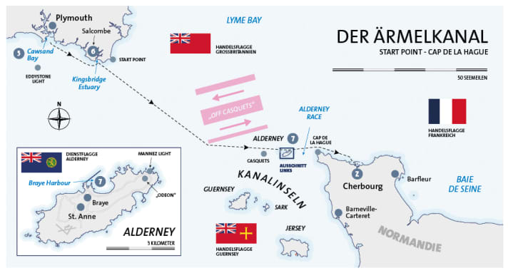
From there we slowly made our way back to the starting point. We finally spent last night in Cawsand Bay, and after dropping anchor in the morning and leaving the long shadows of Rame Head, we set course for the English Channel for the second time. One more stopover, today in Salcombe, and then we'll finally cross the Channel - which is just as well, because we have to be in France in three days' time to hand over the "Rolling Swiss 2" to our successor crew.
English Channel at last
The yacht follows the coast to the south-east for two hours. The estuary of the River Yealm passes by, then Bigbury Bay and finally Bolt Head with its sharp profile. We turn northwards into the Kingsbridge Estuary. The cruising guide reveals that this is a ria, a submerged river delta, which in this case is far too large for its small tributaries and looks more like a fjord. "
Popular with sailors and holiday makers," it continues. Salcombe, which has made itself comfortable about half a nautical mile behind the barre on the banks to the west, is still in the sunshine when the harbour master guides us purposefully to mooring buoy "V 17" with his boat. A cormorant has to vacate its place for us, and soon we are safely moored in the current on double fore lines.
The first views of Salcombe whet the appetite for more: the small craft moorings on both sides of the fairway and the middle ground to the east of the town are full of English yachts, while the beaches to the west (which are somewhat reminiscent of the posh Hamburg suburb of Blankenese on the Elbe) are in full swing at the weekend against a backdrop of lush greenery. Sailing dinghies, SUPs and sports boats of all kinds cruise by, as do ferries and harbour taxis.
Dinghy ready and off we go on a "photo safari", which takes us from the tender pontoon first through the alleyways, then over the rooftops of the town and finally to the Fortescue Inn, over which the evening is dawning. "Salcombe Ale" arrives in glasses with plimsoll load marks, like those on the sides of large ships. The pint is quickly drained. Back on board, the remaining itinerary is decided: first to Alderney tomorrow to at least get an impression of the Channel Islands before the last leg to Cherbourg the day after tomorrow.
Long day
When we get up at 5.30 a.m., the river valley is covered in thick fog. The white houses on the banks have been swallowed up by the thick veil. There is still no movement on the yachts around us. But it's supposed to be a beautiful day with only light winds. Twenty minutes later, we slip our mooring lines and turn the bow downstream towards the open sea. We carefully pass the bar between the sharp reefs of Pound Stone and Black Stone. Then the depth increases. Aft, the still low sun begins to burn purposefully through the fog.
It's going to be a long day, we have to reckon with ten to eleven hours to Alderney. So, for the first and only time on this trip, we have two watches of three hours each. Morten and I start, the others lie down again.
The English Channel is crossed
The direct route would take us through the "Off Casquets" traffic separation scheme, which we need to avoid. So we first head a little further west to aim for the south-west corner of the VTG. The autopilot steers 123° for this. At the beginning, however, we make a few turns to avoid fishermen and their buoys, which fortunately can be spotted early on in the almost smooth sea. Over there, the rather old boats are hard at work. Clouds of seagulls wait for what is about to drop. We pass the "Tenacious", the "Quest" and the "Jack G", while the high coast of England slowly dissolves into the haze. After the short night, the early morning on the bridge is a little slow. "Supercharger" helps, an extra strong brand of coffee.
At around 11 a.m., we begin to cross the main fairway, which is many nautical miles wide. The traffic to the west is lined up one behind the other like a fleet in keel line: container feeders, a rusty Russian tanker, high-sided car transporters. Wide AIS arrows on the plotter. A little later in the opposite direction, there isn't quite as much going on, but the 290 metre long "Hyundai Supreme" is making so much speed at 16 knots that we also have to hurry to keep a safe distance from her foaming bow wave.
The light breeze that had picked up from the west in the meantime had already collapsed again when we changed course south of the separation area to E - and headed straight back into the fog. A real surprise given the blue sky above us. Visibility is just two boat lengths. Thanks to radar and AIS, however, we don't have any major problems. Nothing changes for the remaining three hours; we use the free time for the first and last sunbathing on the foredeck, which deserves the name. Practical: the fog is excellent for cooling.
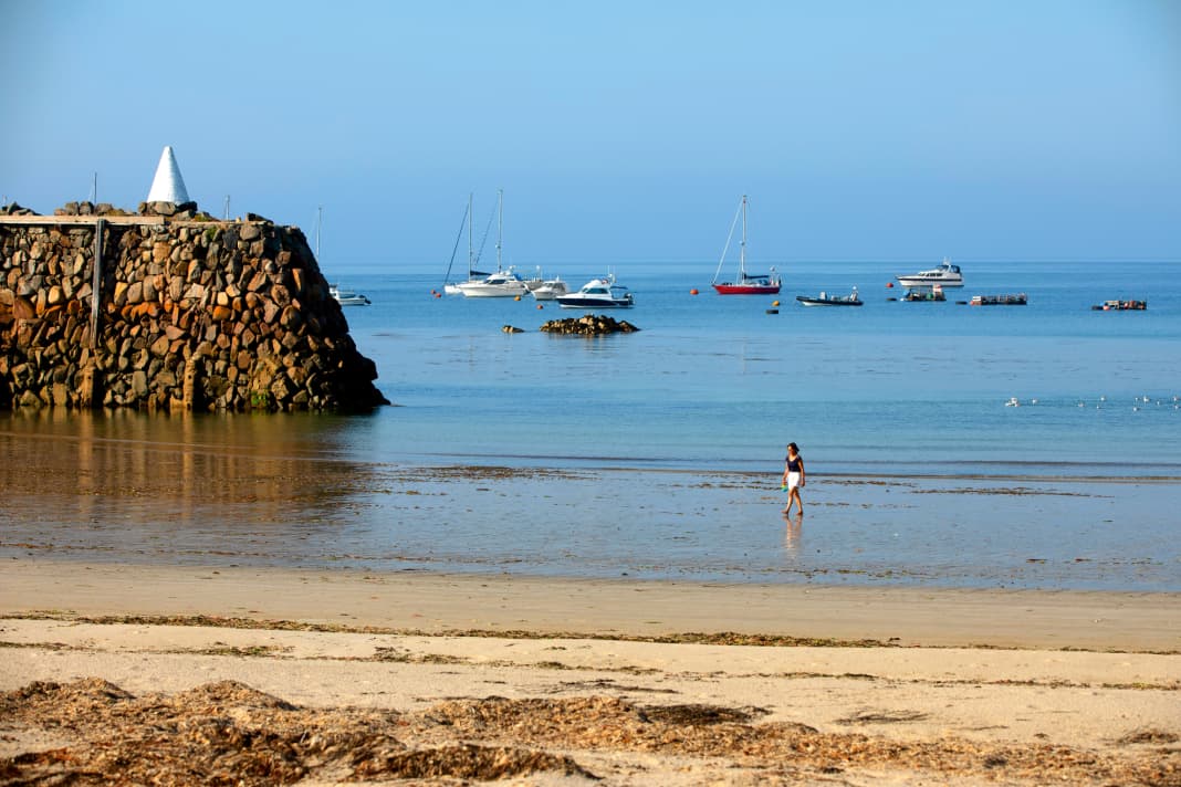
Finally, the veils lift enough for Alderney to appear like a matte silhouette to starboard. We soon round the massive head of Braye Harbour's elongated pier and enter the harbour. The friendly harbour master guides us to a mooring buoy with his flat-bottomed bass boat, helps us tie up and immediately has lots of information at the ready; about clearing in (via form and letterbox), about the food ("Braye Chippy" in the harbour), about the service ("six new showers, better than in Cowes!"). Laughter. In any case, Alderney - whose 2000 inhabitants no longer have a permanent ferry connection "to the outside world" - is a very boat-friendly place.
Alderney
The panorama promises a lot: rocks, sand dunes, lots of fortifications, from Victorian forts to Atlantic Wall bunkers, small forests and lost white houses. Great beaches! We go ashore in the dinghy: high piers, a wheeled crane for unloading the supply ship and a container labelled "Alderney" welcome us. In between, the usual litter of all the harbours in the world: fish crates, lobster baskets, old fenders, sand and cracked concrete. Scraps of green nylon mooring lines waft through the barbed wire. There is a slight misunderstanding at the sailing club about the local time: is it five or six o'clock? Five, of course - after all, you're "in England". However, at least here they are talking about France instead of the continent.
We drink our carling on a bench overlooking the basin of the almost dry inner fishing harbour and pick up a guest flag from Alderney in the local chandlery (a small shed with a tattooed blonde girl behind the counter) - more of a souvenir, given the short stay.
Afterwards, we pack up our things to hike to the Mannez lighthouse. Beautiful evening light and silence, deserted houses with the wind blowing around them, an almost deserted campsite and screaming seagulls. You stumble across bunkers everywhere. The "Odeon" near the lighthouse stands out in particular, looking like a film palace in the Art Deco style of the 1930s. From its box seat on a rocky ridge, it overlooks the west of the island. Behind its elegantly curved façade, the German coastal artillery concealed fire control and rangefinders.
Back to Braye Beach, where we spend the last quiet hours and the last sunset of the trip on a lonely bench. We pop into the "Divers' Inn" in the harbour, where skipper Marc tries to get rid of his last Guernsey pounds.
Together with the larger neighbouring island, Alderney forms an independent administrative unit directly owned by the Crown. They are not even part of the United Kingdom - and that means they have their own flag and their own money, even if they have just 65,000 souls.
Three of these locals are making music tonight with guitar, violin and vocals. Fishermen who sing about farming. Or maybe it's the other way round. A little off-key, but all the more atmospheric for it. We drink "Doom Bar" from Cornwall, which is named after a disastrous riff and therefore rather fitting, and have the definite feeling that this visit to the island was far too short. Which doesn't stop us from enjoying it to the full.
On to France
Nevertheless, at 7.30 a.m. it's time to say goodbye again after our flying visit. We untie the lines, pick up speed - and find ourselves in fog again shortly after the pier. Compared to yesterday, it is noticeably thicker, greyer and wetter. The sun only shimmers above us as a pale white disc. So we head out onto the Alderney Race with no visibility. The eight-mile passage between the eastern tip of the island and Cap de La Hague in the north of Normandy is notorious for its extreme tidal currents.
The tide is travelling at up to twelve knots here. Speeds at which standing waves form in notorious places - rapids on the open sea. Even with two powerful Cummins diesels in the stern, this size must be taken into account when planning a trip, especially when the wind is against you.
Even in calm conditions like today, we can feel the ebb current pushing against the "RS 2": the yacht bucks and lurches. But apart from that, the only thing that causes concern is our increased fuel consumption, as we want to keep our eight knots above ground. We still have a lot to do in Cherbourg. To do this, we have to increase the revs from 1400 to 1900 for a good hour. We use the time to "unrig" the recently hoisted Lion of Alderney on the starboard side. Now the French tricolour flutters in the breeze.
The fog is finally drawn away from the English Channel like a curtain, and the flat, friendly coast of the Cotentin peninsula lies pale blue to starboard. There are only a few rocks to be seen, but plenty of beach. Behind it, gently rising fields. The lighthouse at Cap de la Hague shines brightly in the sun. Less than two hours later, the harbour of Cherbourg announces itself with its long pier. Also dotted with the forts and bunkers of the centuries, it lies like a fortress wall protecting the Grand Rade - the Great Roadstead. Many fishing boats are out and about here and the clear water is teeming with fish. The last nautical mile takes us to the petrol station at Port Chantereyne. The marina is by far the largest on this trip, which is also due to Cherbourg's central position in the canal.
In addition to French flags, there are also plenty of British flags fluttering on the countless long pontoons, as well as Dutch, German, Belgian and Swedish flags. There is a lot going on: the flotilla of British Princess owners is just arriving from the Solent, eight yachts in all. At the same time, an armada of Optis is leaving, neatly tied together and towed by a RIB. In between, the captains keep order with their own boat and allocate berths. We can go alongside at the head end of pontoon P. Lines tied up, engines off - and that marks the end of our seventh season together with the CCS.
The air hangs over the harbour. Thirty degrees in the shade. You start sweating just thinking about tidying up. A look in the on-board fridge on the aft deck: it doesn't look good, just an emergency ration. After a full wash for the "Rolling Swiss 2", we stroll past the dock, where a red trawler is waiting lonely for the hammer, and then along the outer harbour full of fishing boats and the almost empty fishing harbour.
On the way, cheers echo from a side street, public viewing is going on somewhere - and the French have just scored the decisive second goal against Uruguay on their way to the World Cup final. Young people sit in a small park near the marina and savour the weather: Wine bottles are clinking, cigarettes are smoking and the glow of the early evening is reflected in their sunglasses. The fact that we are suddenly in France doesn't quite sink into our heads yet. We have made it. Conquered the English Channel. Liberté toujors!
Precinct information

Cruising stages
5. Cawsand Bay - Salcombe: 21 nm
6. Salcombe - Braye Harbour (Alderney): 76 nm
7th Braye Harbour - Cherbourg: 26 nm
Z Cherbourg
Total distance (second half of the trip): 123 nm
Total distance (cruise): 269 nm
Literature
Recreational craft chart sets SC 5602 "The West Country. Falmouth to Teignmouth" and SC 5604 "The Channel Islands". British Admiralty: A2, price: €72.20 each. www.hansenautic.de
Harbour and area handbook "The Channel Islands, Cherbourg Peninsula, and North Brittany" by Peter Carnegie (2018). Imray: 396 p., A4 format, hardcover, ISBN 978-1-8462-394-34, price: €56.80. Order via www.hansenautic.de

Tip
Hello, Taxi! Apart from the commercial marinas, moorings with shore access are rare in the area. If you are moored at anchor or at the mooring ring and don't have a dinghy (or don't want to put it in the water), you can call a taxi boat for shore leave (usually by radio). One-way trips cost the equivalent of between 2 and 4 euros.
Our harbours
Booking is customary. Moorings and murings are allocated by radio, telephone or on site Cawsand: Cawsand Bay Anchorage ▪ Salcombe: Salcombe Harbour moorings, www.salcombeharbour.co.uk ▪ Braye Harbour: Braye Harbour moorings, www.visitalderney.com/visit/sailing/information ▪ Cherbourg: Port Chantereyne, www.portchantereyne.fr
The club
We travelled the English Channel with the Cruising Club of Switzerland (CCS). With around 6,500 members, the Bern-based Central Club is one of the largest water sports clubs in Switzerland and is a leader in deep-sea training for pleasure craft. The motorboat division forms its own subdivision within the club with its own yacht, which is used for training and travelling trips in northern and western Europe. www.ccs-motoryacht.ch
Our boat
Type: Trader 42 (GRP semi-planing) - Length: 13.30 m - Width: 4.30 m - Height: 3.80 m - Draft: 1.20 m - Berths: 6 (3 double cabins) - WC/shower: 2/2 - CE category: A - Motorisation: 2 x 380 hp - Special equipment: VHF radio system, plotter with radar and AIS overlay, generator, EPIRB, dinghy
Driving licence
Skippers on their own keel and with a German residence require an official recreational craft licence with the scope of validity Sea.
The precinct
The English Channel (French: La Manche) is an arm of the North Atlantic with a length of around 550 km (300 nm), its narrowest point is the Strait of Dover with a width of just under 30 km (16 nm). The density of maritime traffic there is among the highest in the world. In nautical terms, the canal is divided into an eastern and western part (dividing line approximately at Cherbourg) or (from the west) into the four sea areas "Plymouth", "Portland", Wight" and "Dover". Two traffic separation schemes are designated: "Off Casquets" and "Strait of Dover". In accordance with collision prevention regulations, these VTGs should only be used in exceptional cases (and then at right angles to the direction of traffic). The pronounced tidal courses require precise planning and exact navigation, especially when navigating close to the coast and travelling in the area. The coastline is rocky, and shoals and reefs are frequent, especially in the Channel Islands.
The Collision Prevention Rules (KVR) apply to navigation, buoyage and lighting of the fairway are appropriate. VHF radio equipment is common in the area and is an important safety factor. Sea rescue: Royal National Lifeboat Institution (British area of responsibility, rnli.org ), Société Nationale de Sauvetage en Mer (France, snsm.org ).

