Territory portrait: Channel Islands - The five friends


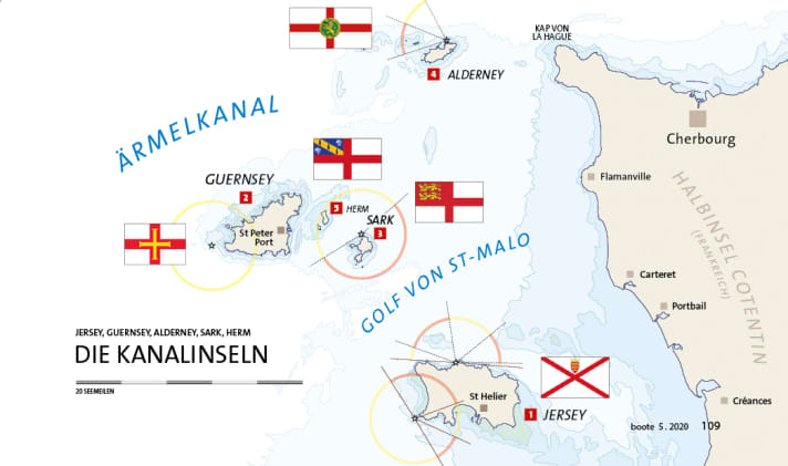
The archipelago is located in the south-western part of the English Channel - just off the French coast in the Bay of St Malo. The writer Victor Hugo described them as "pieces of France thrown into the sea that England has picked up". They are not politically part of the United Kingdom. But despite their much closer geographical proximity to France, the islands are thoroughly British in terms of culture: there are pubs, fish and chips and deckchairs.
From a British perspective, Jersey, Guernsey, Alderney, Sark and Herm are foreign countries, and yet they belong to the Crown. This peculiar situation dates back to 1204, when King John lost almost all his mainland possessions and earned himself the nickname "landless". His vassals were allowed to choose between the Norman duchy and the English crown. They decided against France and in return received privileges in the form of their own legislation and tax sovereignty, which have been preserved to the present day. Today, fishing, privateering and wool processing are no longer the main sources of income, but the islands are considered an offshore financial centre for investors from Great Britain, far ahead of agriculture and tourism.
Geologically, the Channel Islands are the remains of peaks that only became islands when sea levels rose after the last ice age. Jersey and Sark consist of flat plateaus with high coasts, while Guernsey, Alderney and Herm, which lie further north, slope from south to north and have flat beaches in the north. Each of the islands has its own unique charm.

1. jersey
49°13' N; 002°7'
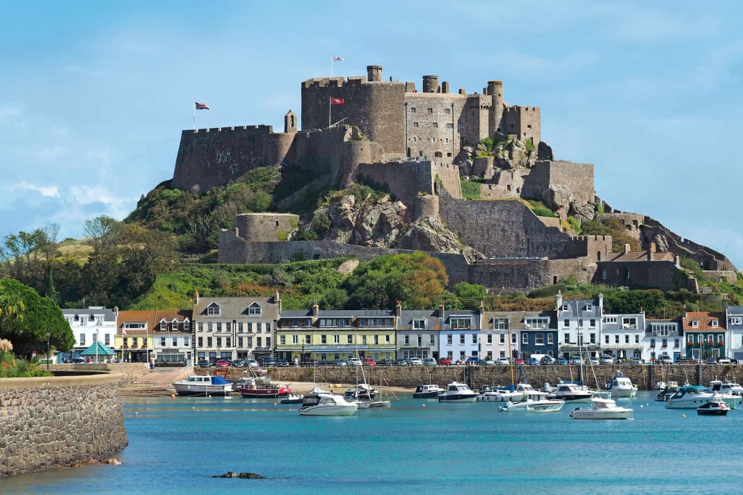
It's hard not to rave about the island. There are golden sandy beaches to suit every taste. Surfers head for the Atlantic surf on the four-mile-long St Ouen's. Families flock to St Brelade's, a huge stretch of sand lined with hotels, cafés and 'bucket and spade' shops. Those who enjoy walking can do so along the wild cliffs on the north coast. The island offers a number of first-class attractions. Top of the list is Jersey Zoo, which aims to save animals from extinction (and therefore appeals to many who don't normally approve of zoos). The Jersey War Tunnels are also worth a visit. A German legacy from the occupation during the Second World War, the tunnels house an underground hospital, among other things. A visit to Elizabeth Castle is also worthwhile, especially at high tide if you are travelling on the amphibious "puddle duck" (a converted old Bedford lorry).
2. guernsey
49°27' N; 002°35'
Guernsey has by far the most beautiful harbour of the five Channel Islands: St. Peter Port, albeit with a tidal range of around ten metres. Stone bars in the entrances to both harbour basins ensure that the marinas do not run dry and that the water depth inside is still two metres even at low tide. You can only enter the harbour during a certain high tide window (around 2 ½ hours before and after high tide). If you arrive at low tide, go to standby at a floating pontoon in the forebay and keep an eye on the Victoria Marina traffic lights. The harbour staff will help with mooring and casting off. The town offers two of the island's main attractions: Castle Cornet - an 800-year-old fortress that guards the harbour, and Hauteville House, which was lavishly and eccentrically designed by its former owner Victor Hugo.
Inland, much of Guernsey feels a little claustrophobic, with too many greenhouses (horticulture is big business) and lots of traffic. The number of open-top sports cars is amusing, as the speed limit on the narrow country roads is 30 km/h. Pedestrians, cyclists and horses are often almost faster. Guernsey's real attraction is its coastline: A series of striking sandy and rocky bays run to the west: Vazon, popular with surfers, or Pembroke and L'Ancresse. The south-east corner is Guernsey at its most beautiful. Wooded valleys lead to idyllic sandy coves such as Petit Bôt, and the coastal footpath, which follows the high cliffs around the Icart and Jerbourg peninsulas, offers breathtaking views along the east coast to St Peter Port.
3rd Sark
49°26' N; 002°21'
Travelling to Sark is in many ways like taking a trip back in time. Tractors are the only motorised transport permitted. Visitors can get around on foot, on hire bikes or by horse and cart. Sark consists of two high rocky islands, Great and Little Sark, which are only connected by a short ridge up to 100 metres high. The island consists of a high plateau surrounded by very steep cliffs. Windy paths intersect with wild flowers and meadows and lead through subtropical forests to the coast. A hike can be combined with frequent pit stops in the many tea rooms and the beautiful gardens of La Seigneurie
4th Alderney
49°43' N; 002°12'
This island is an unconventional outpost - if you're lucky, you can travel on a London Underground train at the weekend, powered by an old diesel locomotive. Despite having an airport and cars on the island, Alderney feels like the most remote Channel Island. Unlike Sark and Herm, few day trippers are drawn here. Those who arrive by boat are greeted by a wild coastline with Victorian and German fortifications. St Anne is a pretty little town with pastel-coloured Georgian houses. Most visitors come here for the walking and wildlife. There are more than 50 miles of footpaths and the variety of wild flowers and birds is exceptional. The Alderney Wildlife Trust has an information centre in St Anne and offers guided walks. Well worth a visit.
5. herm
49°28' N; 002°27'
Herm is the smallest inhabited island and can be circumnavigated on foot in two hours. The island has been managed by the same tenant family for more than 50 years, with the express aim of maximising the beauty and tranquillity of the place and the enjoyment of visitors. Neither cars nor bicycles can be hired. Signposts indicate walking times to the minute. It is not permitted to listen to the radio outdoors. The footpaths lead to cliffs where the manor house and the island school (currently with only eight pupils) are located. Shell Beach is a 500 metre long beach lined with low dunes with strips of (mostly crushed) pink and gold shells. There is a small café there. The two pubs and three souvenir shops are located by the ferry terminal.
Service
Nautical information
Overview As they are surrounded by shallows, the Channel Islands can confidently be described as a challenging area. The tidal range and the associated currents are among the strongest in the world. In strong wind-versus-current situations, it is important to avoid certain passages between the islands (if you don't want to find yourself in a whirlpool). There are three golden rules that the British coastal handbook recommends: "Know the weather forecast, keep an eye on the tide, know your exact position at all times."
Navigation Although the islands are considered the most south-westerly part of Great Britain, they are often subject to the typical mix of British weather (four seasons a day) despite the influence of the Gulf Stream. West to north-west is the most common wind direction. A low over the Atlantic can make for extremely uncomfortable conditions. This is accompanied by higher swell, which makes most anchorages on the smaller islands unusable. In general, the following applies to the passages: it is better to avoid a wind-against-wave situation. Unpleasant overfalls can occur in some shallow places. Otherwise, the area is very well buoyed, which ensures good orientation. And just as important before setting off: take a look at the tide table, otherwise the planned stage will be a strenuous affair due to the strong tidal currents.
Weather/climate

Literature
Coastal handbook "Channel Islands, Cherbourg Peninsula and North Brittany" - ISBN 978-1-84623-943-4. 56,80 Euro. Available in English from IMRAY at Hansenautic. www.hansenautic.de

