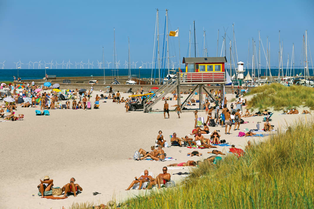


Anyone who thinks that Sweden is all forests, lakes and archipelagos should take a look at Skåne. In summer, sun-seekers flock to its white beaches. The Caribbean may come to mind - at least by Scandinavian standards. In any case, the level of relaxation is tropical, a certain lightness of being is even mandatory, on land and at sea, in the harbour and at anchor - completely independent of the water and air temperatures. Because one thing is certain: the next Nordic winter is sure to come!
The Öresund stretches for around fifty nautical miles off the shallow coast. It not only separates the Western Baltic Sea from the Kattegat, but also Sweden and Denmark. Nowhere else are the two neighbours as close as at Helsingborg and Helsingør. The ferries travelling between the two cities have to cover barely two and a half nautical miles.
The other fixed link is the fourteen kilometre long road and rail crossing, inaugurated in 2000, which has transformed the opposing metropolises of Copenhagen and Malmö into a single urban space, separated from the water yet united, with a combination of tunnel and bridge - the Øresundsbron. This marriage cost one billion euros.
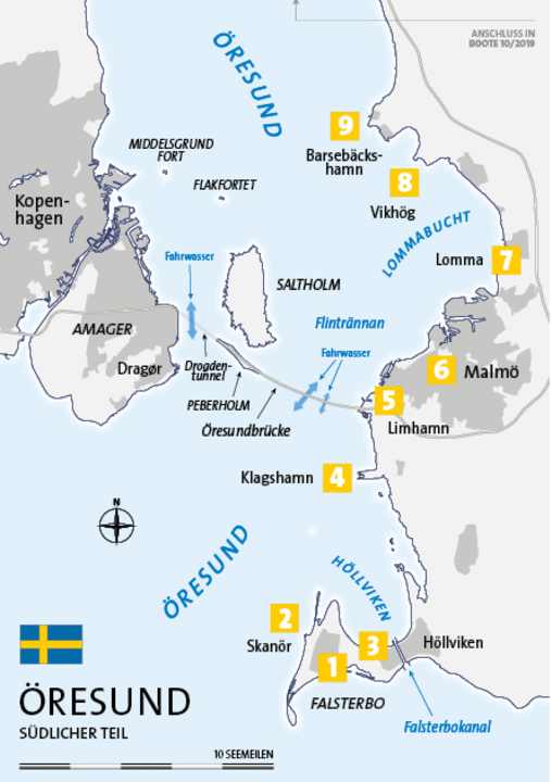
But for this portrait of the area, we're staying on the Swedish side: because the Swedish side of the Sound has a lot more to offer than just warm sand: almost twenty marinas are spread along the coast between the two peninsulas of Falsterbo in the south and Kullen in the north. These include small community harbours as well as large marinas, idyllic places in the countryside and lively ones with a big city flair. The first part of our two-part series shows the southern half of the region, from Skanör up to Lomma Bay north of Malmö.

1st Falsterbo
The southern end of the Öresund harbours a particular challenge for all ships wishing to pass through. The Falsterbo peninsula juts out into the Baltic Sea like a sandy hook with reefs far offshore - a treacherous obstacle, especially in the days of sailing ships. Nowadays, thanks to modern technology, the passage is not only much less nerve-wracking, but also takes less time. Since 1941, a canal (originally built for military reasons) has cut through the Falsterbos base. The waterway, which is just under two kilometres long, is spanned by a bascule bridge at Höllvik, which opens at certain times between 6 a.m. and 10 p.m. during the season. The times can be found on the Internet ( www.sjofartsverket.se > Search: falsterbokanalen), and the bridge can also be reached on VHF channel 11. When closed, the clearance height is 3.90 metres.
2nd Höllviken
The pretty houses of this holiday settlement in Sweden, which takes its name from the neighbouring bay to the north, lie in dense forest on both sides of the Falsterbo Canal. North of the bascule bridge, which carries the only access road to the peninsula, the canal exit is flanked by two long piers. On its western side, the harbour of the Falsterbokanal Båtklubb uses this protection. The facility offers a full range of services and there are places for guests ( falsterbokanalen.se ). The lidos on the south side of Falsterbo are also within walking distance from here, as are the pizzeria, bakery and supermarket.
3. skanör
Skippers who do not choose the route through the canal, but rather the classic route "around the outside", cannot avoid Skanör in the truest sense of the word. Although the old main town lies around one kilometre inland, beyond the dune belt and salt marshes, it also has a harbour. A sufficiently deep, newly dredged channel leads to the entrance of the semi-circular basin. Originally created for the loading of cement, this magnificent spot now only belongs to holidaymakers ( www.skanorshamn.se ). Moor up and let your holiday in Sweden begin!
Fish smokehouses, snack bars and the chic "Badhytten" (with a view over the beach; badhytten.com ) ensure that even those crews who don't fire up the barbecue themselves are well fed. Speaking of the beach: it's right next door and is one of the most beautiful in southern Sweden. The historic town centre with the medieval St. Olof's Church, more restaurants and the supermarket can be reached by bike or on foot. A little further on is the path along the coast through a nature reserve to the southern tip. A detour leads to the Falsterbo lighthouse, which now stands on a golf course.
4th Klagshamn
Before heading to the lively centre of Malmö, Klagshamn is a good place to take a break. This harbour ( www.klagshamn.nu ) dates back to the former lime and cement industry. Since this year, however, the wooded headland of Klagshamnsudden, at the tip of which it lies, has been designated a nature reserve. Here, too, the quite natural beach is only a few hundred metres away.
5 Limhamn
If there is no space available in the centre of Sweden's third largest city, Malmö's Limhamn district just north of the Öresund Bridge is a good alternative. There are two fully equipped marinas here, with småbåtshamn to the south being the largest in the area with 1000 berths ( www.smabatshamnen.se ). Everything is available, from a 5.5-tonne crane to a boat wash, and technical services of all kinds are easy to organise. The supply is just as good as the connections: Bus lines 4 and 7 take you directly to the centre of Malmö ( www.skanetrafiken.se ).
6 Malmö
The rivalry between the two large cities on the west coast of Sweden goes back a long way. Malmö has never quite been able to keep up with the elegant solidity of Gothenburg. However, there is no longer any need for it to do so, as in the past two decades it has stepped out of the shadow of its bigger sister in its own way. This has a lot to do with the transformation of Västra Hamnen: The former industrial site, once home to one of the largest Kockums shipyards in the world, is gradually becoming a second centre of Malmö. Various concepts of modern urbanity are merging here in terms of planning. The district is dominated by the Turning Torso, Scandinavia's tallest building at 190 metres. The twisted, futuristic structure, opened in 2005, is also an unmissable landmark from the sea with its white façade. Visits with a panoramic view are possible (registration: www.turningtorso.se ).
Where Västra Hamnen meets the Öresund, it really comes alive on beautiful evenings: People stroll along the promenade, dance, swim or simply watch the late sunset. Bars and restaurants line the promenade. If you prefer something more natural, you can stroll to the neighbouring Scaniaparken to the north or to the beach at Riberborg to the south. Guests have two alternatives: firstly, the small Västra Hamnen directly on the promenade. The lighted entrance is via the Turbinkanalen ( www.malmo.se > search term: båtplatser). The second is Dockan Marina, which is located in the former dry dock of Kockums (approach via the main harbour; www.dockanmarina.se ).
7. lomma
Further north is the small town of Lomma at the mouth of Höje Å into Lomma Bay. The guest moorings are primarily located on both sides of the river, with larger boats going alongside on the north bank ( www.lbs.nu ). There is also a beach here. But what is particularly interesting is the proximity to the university town of Lund, ten kilometres inland, with its medieval centre, many student cafés, the historical museum and the twin-towered cathedral ( visitlund.se ). Bus route 139 takes only twenty minutes from Lomma ( www.skanetrafiken.se ).
8th Vikhög
The small fishing and holiday village is completely relaxed. If you are looking for a rural environment again after Malmö, this is the place for you. Guest places in the harbour are marked in green ( www.svenskagasthamnar.se > vikhög).
9th Barsebäckhamn
The last stop on the way to the next larger town of Landskrona is the holiday resort of Barsebäckshamn ( www.barsebackshamn.eu ). As in Vikhög, you are in the immediate vicinity of the Barsebäck nuclear power plant, which is only about one kilometre away (but has been shut down since 2005) and can be visited ( www.uniper.energy/barseback/en ). With the striking silhouette of the reactor blocks behind you - dismantling is due to begin next year - you can then plan the next stage comfortably on the terrace of "Barsebäcks Hamnkrog" ( www.barsebackshamnkrog.se ).
Service
Distances
- Kiel-Schilksee-Skanör: 128 nm
- Lübeck-Travemünde-Skanör: 115 nm
- Rostock-Warnemünde-Skanör: 80 nm
- Klintholm Havn-Skanör: 36 nm
- Skanör-Klagshamn: 8 nm
- Klagshamn-Malmö (Dockan): 10 nm
- Malmö-Copenhagen (Tuborg Havn): 16 nm
- Malmö-Lomma: 5 nm
- Lomma-Barsebäckshamn: 8 nm
- Barsebäckshamn-Landskrona (Nyhamn): 8 nm
- Landskrona-Helsingborg (Norra Hamnen): 13 nm
SEA MAPS Delius Klasing sports boat chart set 4 "Great Belt to Bornholm". Single charts in 60 x 42 cm format (A2) in plastic pouch, 4 over-sailors, 33 area and detailed charts, area guide (108 p.) with area information and waypoint list including 60 harbour plans, with digital nautical chart for "Yacht Navigator", ISBN 978-3-667-11603-1, price: 79.90 €. www.delius-klasing.de
PORT GUIDE Harbour Guide "Denmark and Southwest Sweden" by Per Hotvedt, 3rd edition (2019), with all important nautical information, aerial photos and plans of harbours and anchorages. 308 pages, 434 illustrations, format: spiral binding, 22.5 x 30 cm, ISBN 978-3-667-11346-7, price: €69.90. www.delius-klasing.de
The TOP 3 in the district
- Morning in Lund: By bus from Lomma to the student city, historical sightseeing, then sweet brunch with wienerbröd in "Mormors Bageri" ( www.mormors.se )
- Afternoon in Skanör: From the ship directly to one of the most beautiful beaches in the south of Sweden. Refreshment is provided by the bar of the "Badhytten" ( www.badhytten.com )
- Evening in Malmö: The Sundpromenade at sunset, followed by a late swim - almost like the Mediterranean. The pasta and pizza are served at "V.e.s.p.a" ( vespa.nu )
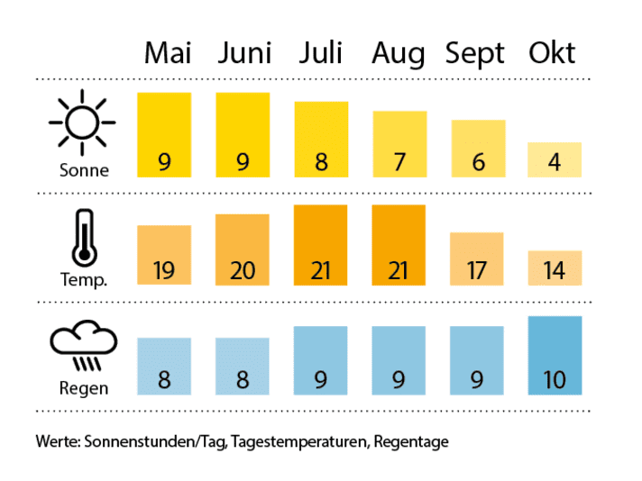
Weather/climate


